
![]()
![]()
From the point of view of hydrodynamics, a classification scheme for estuaries is useful if it identifies the major forces or processes acting in the estuary. The discussion of the last chapter developed a logical classification sequence based on a single non dimensional parameter, the ratio $R/V$. Non dimensional parameters always measure a balance between two forces or processes. (Recall the Richardson number from Chapter 3 which compares the stabilisation of a stratification from buoyancy with the destratification from turbulence, or the Reynolds number of Chapter 7 which compares the inertial force with the frictional force.) Use of a single parameter therefore implies that all estuarine property fields are determined by only two processes. Brief reflection proves that this is an over-simplification and that we have to consider more processes to cover all possible situations.
To begin with, contours of constant velocity (isotachs) differ markedly from contours of constant salinity (isohalines). This indicates that the velocity field and the salinity field cannot both be governed by the same balance of processes. The direction of the flux of momentum, which is normal to the isotachs, differs from the direction of the salt flux, which is normal to the isohalines; in other words, the effect of turbulent diffusion on the transport of momentum and on the transport of salt is different. The non dimensional number which compares the turbulent diffusion of momentum (friction) with the turbulent diffusion of water properties such as heat or salt (mixing) is known as the Prandtl number, $Pr$. It has to be expected that $Pr$ plays a role in determining the type of estuary.
The forces which determine the mean velocity field involve the longitudinal pressure gradient which determines the advection, buoyancy (the combined effect of gravity and stratification) which determines the stability of the water column, and turbulent diffusion of momentum (friction). Comparison of three forces requires two ratios. Because turbulent diffusion is the result of tidal currents, one way of comparing it with the pressure gradient is the use of the ratio $R/V$ known from Chapter 11. Comparison of turbulent diffusion with water column stability is achieved through the Richardson number $Ri$. A complete description of an estuary thus requires three non dimensional numbers, for example $R/V$, $Ri$ and $Pr$, and a hydrodynamic classification would have to group estuaries together in accordance to their values. Other non dimensional numbers could, of course, be used; but from the foregoing considerations it is clear that three such numbers are required for a complete description and that all possible sets of three such numbers can be transformed into each other.
The theoretical foundations for a hydrodynamic classification scheme for positive estuaries were laid by Hansen and Rattray (1965). They introduced the densimetric Froude number $F_m$, the mean velocity ratio $P = u_f/ u_t$, and the diffusive salt flux fraction $\nu$. A brief discussion of these numbers is necessary before we proceed to a description of the classification scheme itself.
The velocity $u_f$ is defined as the cross-sectional average of the vertically averaged mean velocity. As discussed in Chapter 11, it is given by $R/ (AT)$, where $A$ is the cross-sectional area and $T$ the tidal period. The velocity $u_t$ is defined as the cross-sectional and vertical average of $\sqrt{u^2}$, where $u$ is the tidal velocity; it is thus equal to $V/ (AT)$. The ratio $P = u_f/u_t$ is thus equivalent to our earlier ratio $R/V$.
The salt flux fraction $\nu$ is defined as the fraction of the total salt flux into the estuary that is achieved by horizontal diffusion. The significance of this parameter is understood when we remember our empirical classifications of Chapter 11. The salinity field of the highly stratified estuary was dominated by entrainment, ie upward flux of salt with little or no horizontal diffusion; it can therefore be expected to be associated with values of $\nu$ very close to zero. Salinity in the vertically mixed estuary, on the other hand, is completely determined by horizontal diffusion and therefore associated with $\nu =1$. While this points towards some relationship between $R/V$ (or $U_f/u_t$) in field situations, it is clear that the dynamic reason for the different salt diffusion processes are the different directions of the salt flux and of the momentum flux, ie a difference in Prandtl numbers. The salt flux fraction parameter $\nu$ is therefore the equivalent of the Prandtl number.
The densimetric Froude number $F_m$ is defined as
\begin{equation} F_m \equiv \dfrac{u_f}{\sqrt{(\Delta \rho /\rho) g H}} \label{eq:froude} \end{equation}
where $g$ is gravity ($9.8\; m\;s^{-2}$), $H$ the depth of the estuary, $\Delta \rho$ the density difference between surface and bottom and $\rho$ the vertically averaged mean density. Considering that the Prandtl number is equivalent to $\nu$ and the ratio $R/V$ equivalent to $P, F_m$ has to take the place of the Richardson number $Ri$. This can be seen as follows.
The Richardson number $Ri$ was defined in Chapter 3 as
\begin{equation} Ri \equiv \dfrac{\dfrac{g}{\rho}\dfrac{d \rho}{dz}}{\left(\dfrac{d u}{dz}\right)^2} \label{eq:ri} \end{equation}
In the context of estuarine dynamics, $u$ and $\rho$ stand for the mean velocity and density, and $Ri$ represents a tidal mean Richardson number, which is a function of depth. We can derive a single bulk Richardson number by replacing the density and velocity gradients by their surface to bottom differences and write
\begin{equation} Ri_b \equiv \dfrac{(\Delta \rho/\rho) g H}{(\Delta u)^2} \label{eq:rivol} \end{equation}
where $\delta \rho$ and $\delta u$ are the density and velocity differences between the surface and the bottom. The Froude number is the square root of $1/Ri$, so the bulk Froude number is
\begin{equation} F_m \equiv \dfrac{ \Delta u}{\sqrt{(\Delta \rho/\rho) g H}} \label{eq:froudevol} \end{equation}
The densimetric Froude number $F_m$ expresses the contribution of fresh water input to the stability of the system. $\Delta u$ in (\ref{eq:froudevol}) is therefore replaced by the mean freshwater velocity $u_f$, which leads to eqn. (\ref{eq:froude}).
Application of these more theoretical ideas to real estuaries is confronted with many difficulties and has not yet been attempted in full rigour. Although Hansen and Rattray (1966) realised the need for more than a single parameter, their final analysis uses only two independent non-dimensional ratios. Scott (1993) gives a theoretical formulation of the circulation in slightly statified and vertically mixed estuaries and shows how their quantities $F_m$, $P$ and $\nu$ are related to a basic set of three non-dimensional numbers. Theoretical development for all types of estuaries is still a task for the future. In the present context, which is concerned more with the application of principles to real estuaries than with the development of theoretical ideas, it seems appropriate to leave these issues aside and follow Hansen and Rattray (1966).
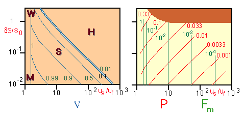 Figure 12.1
In most situations it proves exceedingly difficult to determine $F_m, P$ and $\nu$ from measurements. When looking for properties which are easily accessible to measurement, Hansen and Rattray (1966) decided to use $u_s/u_f$, the ratio of mean surface velocity $u_s$ against fresh water velocity $u_f$, and $\Delta S / S_0$, the ratio of the mean salinity difference between surface and bottom $\Delta S$ and the vertically averaged mean salinity $S_0$. Fig. 12.1 shows how $F_m, P$ and $\nu$ vary with these two observational quantities. $\Delta S / S_0$ represents the salinity stratification, $u_s/u_f$ the convective circulation (expressed through the degree of flow intensification in the upper layer). Determination of these parameters requires the measurement of salinity as a function of depth and of the surface velocity over one tidal cycle, the measurement of river input $R$ over one tidal cycle and knowledge of the topography for the determination of the cross-sectional area $A$.
It is important to remember that fig. 12.1 represents the result of theoretical analysis. However, comparison with the empirical classifications of Chapter 11 proves that it describes the dynamics of many estuaries very well. The vertically mixed estuary, for example, is characterised by very little or no flow intensification (see Fig. 11.6). It is found in Fig. 12.1 at the extreme left of the diagrams, with $u_s/ u_f$ values of 1.5 and less. The salt transport into the estuary is achieved entirely by horizontal turbulent diffusion against the mean flow, indicated in Fig. 12.1 by $\nu = 1$. The vertical salinity gradient is very small, leading to large densimetric Froude numbers (it approaches zero for $u_s = u_f$, where $F_m$ goes to infinity). The ratio $R /V$ is less than 0.005, so $P$ is less than $10^{-2}$. The vertically mixed estuary is therefore contained in the classification scheme of Fig. 12.1 in the region marked M. The salt wedge estuary, on the other hand, is associated with the largest surface to bottom difference in salinity and the largest $R/V$ ratio but little or no flow intensification and is therefore found at the highest values of $P$ in the upper left of the diagrams. It differs from the vertically mixed estuary only in the magnitude of $P$ but has the same high values of $F_m$ and $\nu$.
The remainder of the diagrams is taken up by the range of all possible highly and slightly stratified estuaries. The highly stratified estuary shows the largest flow intensification ($u_s = u_f$ values) with moderate $R/V$ ratios and is therefore found at the upper right, where $\nu$ is practically zero indicating that the salinity field is entirely determined by entrainment. The slightly stratified estuary occupies the central part of the diagrams where flow intensification ($u_s = u_f$ values around 5 - 100) and the fresh water to tidal volume ratio are both moderate ($P$ values of 0.1 and less). The associated ν values in the range 0.2 - 0.8 indicate the simultaneous presence of entrainment and turbulent horizontal diffusion. The Froude number is small in the turbulent regime of these estuaries. It is smallest where vertical advection from the lower into the upper layer overcomes the gravitational stability, ie in the highly stratified estuaries.
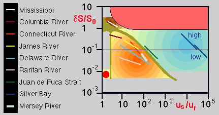 Figure 12.2
By presenting a salinity classification derived from three non-dimensional numbers in two dimensional graphs, Fig. 12.1 excludes many other possible combinations of $P, F_m$ and $\nu$. It is instructive to see how real estuaries fit into these diagrams. The necessary data are not available for many estuaries; but Fig. 12.2 shows the data for six river estuaries and two fjords in northern America and from the Mersey River in England. Variations of freshwater discharge are expressed through changes in $P$. Fig. 12.1 shows that in the $\Delta S / S_0$ vs. $u_s / u_f$ plane, contours of constant $P$ are orthogonal to contours of constant $\nu$. It is seen that estuaries tend to maintain their characteristic $\nu$ values even under very large variations of fresh water input; in other words, the partition between entrainment and horizontal salt diffusion in the establishment of the salinity field remains the same.
The main difficulty with the application of the classification of Hansen and Rattray (1965) is the need for current measurements. Currents reverse twice during a tidal period, and to obtain a reliable estimate of mean velocities requires observations over at least one tidal cycle. The stratification, on the other hand, changes little over a tidal period; it is only regularly moved up and down the estuary for a relatively short distance. A single vertical salinity profile therefore gives an accurate picture of the situation (apart from some uncertainty about the mean longitudinal location of the observed salinity distribution). This explains why the empirical classification scheme of Chapter 11 is still widely used.
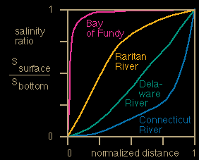 Figure 12.3
There have been attempts to represent the empirical classifications in diagrams similar to Fig. 12.1 and 12.2. Because they are based on a single non dimensional number and are expressed in salinity only, the velocity ratio $u_s / u_f$ cannot be used as unit for the horizontal axis and is replaced by normalised distance $x / L$, where $L$ is the length of the estuary. Various salinity ratios have been employed to scale the vertical axis. Fig. 12.3 uses the ratio of surface to bottom salinity.
Arons and Stommel (1951) showed that the shape of the curves in Fig. 12.3 can be derived from theoretical considerations if the tide is a standing wave and mixing assumed proportional to the tidal velocity. Under these conditions the variation of salinity along the estuary can be derived as
\begin{equation} \dfrac{S}{S_{ocean}} = e^{\displaystyle a(H/\zeta) (R/V) (1-L/x)} \label{eq:frac}\end{equation}
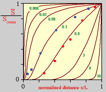 Figure 12.4
where $\zeta$ is the tidal amplitude at the estuary mouth and $a$ is a constant. Fig. 12.4 shows $S/S_{oceà}$ as a function of $x/L$ for different values of $F = (aH/\zeta) R/V$. Note that the vertically averaged salinity is normalised by dividing through the oceanic salinity, so the curves of Fig. 12.4 are not directly comparable with those of Fig. 12.3 where salinity is normalised by dividing through the local bottom salinity. Nevertheless, all curves still have to begin with zero normalised salinity at the head and end with a normalised salinity of 1 at the mouth.
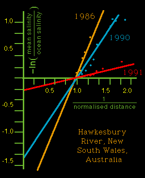 Figure 12.5
The similarity between Fig. 12.3 and Fig. 12.4 is quite striking, even though the salinity variation is not normalised in the same way in the two diagrams. The theoretical formulation of eqn. (12.5) allows us to determine the ratio $R/V$ for any positive estuary from observations of the salinity field and the tidal amplitude at the estuary mouth. Taking the logarithm of eqn. (\ref{eq:frac}) we find
\begin{equation} -\ln (S/S_{ocean}) = F (L/x) - F \label{eq:ln} \end{equation}
A plot of $-\ln (S/S_{oceà})$ against $L/x$ is therefore a straight line with slope $F$ and intercept $-F$, from which $R/V$ can be obtained. In practical applications, $-\ln (S/ S_{oceà})$ is evaluated for a series of stations along the estuary and slope and intercept of the line are determined by linear regression. Fig. 12.5 shows an example.