

![]()
![]()
If the coastal ocean is the region where the continents and the ocean overlap, the estuaries are the place where they really meet. In estuaries, freshwater collected over vast regions of the land pours into an ocean, which sends salt water upstream far beyond the river mouth. Vigorous mixing between the two fluids creates a unique environment, with large potential for life forms able to handle the associated large variability in environmental conditions.
Estuaries are not always associated with drainage from land; but our understanding of estuarine dynamics was formed by pioneering research efforts in the lower reaches of rivers, and the definition of the term estuary is still often based on the assumption that the water of estuaries has to be diluted by freshwater. This is an unnecessary restriction, which we shall not apply. A classical definition of an estuary, still quoted frequently in the literature but based on the assumption which we want to avoid, is
(Cameron and Pritchard, 1963). Estuaries described by this definition are known as positive estuaries. We derive a definition that includes all other types of estuaries by applying three changes. The first change allows intermittent closure of the estuary to the sea. This situation is common with gently sloping, sandy coasts in regions with strong seasonal or irregular fluctuations of rainfall; reduced river runoff during the dry periods allows the establishment of a sand bar, turning the estuary temporarily into a brackish lake. The second change addresses the situation where evaporation exceeds the fresh water supply from rivers and from local rain, and where as a consequence the water in the estuary is more saline than in the open ocean; such estuaries are known as negative or inverse estuaries. The third change, which specifies that estuaries are narrow, is required to separate estuaries from mediterranean seas. We thus introduce the following definition:
How does this definition compare with the preliminary definition given in Chapter 1, which defined estuaries as those parts of the shelf seas where water movement is controlled primarily by thermohaline forcing? Both definitions express the same situation; one does it in terms of empirical observational evidence, the other in terms of hydrodynamics. As discussed before, water movement in the upper open ocean is dominated by the wind driven flow, which is modified in certain places by the effects of thermohaline forces. In contrast, the circulation in an estuary is maintained by the large density differences produced by the salinity contrast between freshwater and oceanic water (or, in the case of the inverse estuary, by the salinity contrast between the hyper saline estuary and the open ocean). The wind may modify the circulation and become a dominant force on occasions, but it is not responsible for the mean circulation over extended periods of time. Water movement in a water body with "measurably different" salinity from the open sea is therefore always the result of thermohaline forcing.
Estuaries are close relatives of mediterranean seas, another category of ocean regions dominated by thermohaline forcing. Chapter 1 distinguished mediterranean seas from estuaries simply by size. The review of deep ocean dynamics of Chapter 2 enables us to be more specific and draw the distinction in terms of hydrodynamic processes. While the forcing mechanism that sets the circulation in motion (horizontal pressure gradients produced by the salinity differences between the water body and the open sea) is the same in mediterranean seas and in estuaries, the balance of forces which maintains the circulation is different. Mediterranean seas are large enough to allow significant water movement normal to their main axis. As a consequence, the influence of the Coriolis force is felt as a deflection of the current from the shortest direction down the salinity gradient (from the freshest water to the saltiest water), and the circulation is nearly geostrophic. Wind forcing also plays a role in some mediterranean seas, where it determines the regions where dense water sinks to deeper layers. The result is usually a complex three dimensional circulation.
In comparison, estuaries are long and narrow and can be approximated in the first instance by a two dimensional structure with no movement normal to the estuary axis. This excludes any deflection of the flow by the Coriolis force; in other words, the Coriolis force needs not be considered in the basic balance of forces. This excludes geostrophy, which proved so powerful and convenient in the deep ocean, from estuarine dynamics. The only force available to balance the pressure gradient along the estuary is friction. In a way, this is similar to the situation in a laboratory tank where water is fed in at one end and runs out at the other, without a chance to move sideways. But friction in an estuary is not so much the result of the mean flow but almost exclusively due to tidal currents. This has important consequences for the salinity field which provides the pressure gradient. In mediterranean seas as in the open ocean, parcels of water maintain their properties over long distances, and exchange of properties occurs through quasi-geostrophic eddies. In estuaries the properties of water parcels are constantly changed by turbulent diffusion on all scales. The estuarine salinity field is determined by the balance between advection by the mean flow and turbulent tidal diffusion. Mathematically, this balance is expressed in a non linear differential equation. Non linear dynamic systems are much more difficult to describe than linear systems. This is because the solution to a linear problem can be found by solving simpler problems first and adding the results. The circulation in the deep ocean, for example, can be described as the sum of geostrophic movement, wind driven flow, tides and eddies. Non linear dynamic systems do not have this additive property, so their solution has to be found in a single attempt that includes all relevant forces. The dynamics of estuaries are therefore much more difficult to analyse than the dynamics of the open ocean.
This inherent difficulty has led to a number of attempts to bring order into the range of possible estuarine circulations and group estuaries of similar characteristics together. The idea is to try and see whether the variety of estuarine conditions can be reduced to a small number of estuary types with distinctly different circulation systems. A number of classification schemes for estuaries resulted from this approach. The remainder of this and the following chapter is devoted to a discussion of different classification schemes and their theoretical foundations.
Pritchard (1952) introduced a classification of estuaries based on topography, which distinguishes coastal plain estuaries (drowned river valleys), fjords and bar-built estuaries. Coastal plain estuaries were formed by the flooding of river valleys following a rise in sea level over geological time. They show little sedimentation, so that the ancient river valley still determines the estuarine topography. These estuaries are shallow, with depths rarely exceeding 30 m or so, and mostly located in the temperate climate zones. Fjords are river valleys deepened by glaciers during the last ice age. The scouring of the valley floor results in very deep estuaries, sometimes exceeding 800 m. The characteristic feature of fjords is the existence of a shallow sill at the mouth formed by accumulated rock at the glacier front. These sills can be as shallow as 4 m, but sill depths of between 40 m and 150 m are more common. True fjords are found only in the temperate zones; but fjord-like estuaries can occur elsewhere as well. Bar-built estuaries are drowned river valleys with a high sedimentation rate. They are thus mostly very shallow, with depths of a few metres, and often branch out towards the mouth into a system of shallow waterways (lagoons). The sediment accumulates near the mouth of the estuary and forms a bar, where the water depth decreases even further. Bar-built estuaries are common in the subtropics and tropics but can occur wherever the coastal zone is characterised by deposition of sediment.
Oceanography is concerned with the circulation and mixing conditions in estuaries, so oceanographic classifications should group together estuaries with similar circulation and similar mixing conditions, ie with similar hydrodynamic behaviour. It is not immediately clear how a classification based on topographic features can help in that respect. We shall therefore leave the topographic classification and explore classifications based on principles of hydrodynamics.
A widely used empirical classification scheme is based on observations of the salinity stratification along the estuary axis. This scheme is best understood if we concentrate for the moment on positive estuaries. Assume that a volume R of fresh water enters the estuary from the river during a given time and that evaporation and rainfall are negligible. For reasons that will become clear in a moment, we measure time in tidal periods and define R as the fresh water volume which enters the estuary from the river over one tidal cycle. If the estuary is in a steady state, the total salt content of the estuary does not change, so the same volume R will have to leave the estuary at its mouth during one tidal cycle. The same argument can be made for any subregion of the estuary; the volume R of fresh water has to enter it at one end and leave it at the other if the total salt content of the subregion is to remain constant. It is seen that in a steady state, the net volume transport at any location along the estuary is constant and equal to the fresh water input R from the river.
The salinity field is controlled by the balance between advection of fresh water, carried by the mean flow R, and diffusion of salt. Obviously, the diffusive salt flux has to be directed into the estuary to counteract the effect of fresh water coming down the estuary. As in the ocean, molecular diffusion is much too weak to achieve the necessary balance, and the diffusion is the result of turbulent motion. The fact that the type of turbulence varies between different estuaries enables us to develop an empirical classification scheme.
The driving agent for the turbulence is invariably the tide. In fact, tidal mixing is so important in estuaries that it can provide the major distinction from mediterranean seas which, on account of their restricted communication with the open ocean compared to their size, are nearly tide free. Estuaries may be narrow, semi-enclosed bodies of water, but their entrance to the sea is wide enough to allow deep penetration of the tidal wave into their lower reaches.
The type of turbulence which occurs in an estuary is determined by the strength of the tide, which can be expressed by the tidal volume, defined as the volume of water brought into the estuary by the flood tide (and again removed by the ebb tide during one tidal cycle.) By comparing this volume V with the fresh water volume R transported by the river over the same period, we derive the first four types of estuaries.
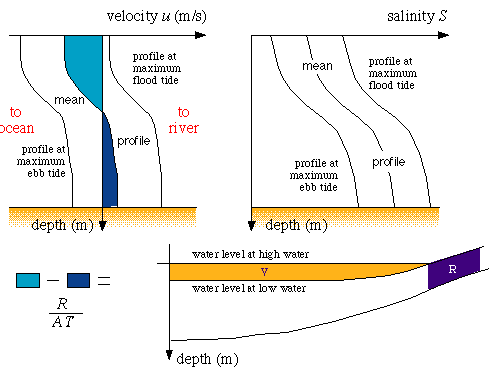 Figure 11.1
It is important to stress again that V and R are quantities evaluated over one tidal cycle, ie quantities characteristic of the time averaged or mean flow. In this and the following chapters, unless the opposite is specifically stated, the discussion, graphs and statements always refer to the mean flow. This flow is associated with a mean velocity profile, ie a mean distribution of velocity with depth, which usually is a function of location along the length of the estuary. The vertical integral over the velocity profile multiplied with the cross-sectional area of the estuary gives the net volume transport M which, as demonstrated above, is independent of the profile's location and equal to R divided by one tidal period (units of M: m3 s-1, units of R and V: m3). The actual velocity profile at any moment in time depends on the phase of the tide and may show current reversal in time, with inflow at all depths during flood tide and outflow at all depths during ebb tide (Figure 11.1).
To distinguish between the instantaneous values of a property p, its tidal average and its various averages in space, we use the term mean p for values averaged at a given point over one tidal cycle. Vertically averaged p refers to values averaged from the surface to the bottom; consequently, vertically averaged mean p is the tidally and vertically averaged value. The cross-sectional average of p refers to values of p averaged from one bank of the estuary to the other bank. Readers may test their understanding of these terms by verifying that, by definition, the cross-sectional average of the vertically averaged mean velocity is given by R/(AT), where A is the cross-sectional area and T the tidal period.
The fact that, with very few exceptions, the mean velocity profile shows flow towards the sea near the surface and flow into the estuary near the bottom and goes through zero inbetween, can be used to describe an estuary in terms of two layers. This is a convenient aid for the description which we shall use frequently. Adoption of a two layer model for an estuary should not be understood as implying that the two layers have uniform salinity, which is rarely the case. But by definition, the mean flow in the upper layer is directed towards the sea, the mean flow in the lower layer into the estuary, and the interface between the two layers is at the depth of zero mean flow.
Another important point to note again is that the character of an estuary is determined by comparing the volumes V and R. If the flow of freshwater through the estuary is small, then a small tidal volume can produce just as much mixing as a large tidal volume can achieve against a large fresh water flow. The absolute size of V or R is therefore not of interest for the classification of estuaries; the relevant quantity is the ratio R/V.
If the tidal volume V is small compared to the fresh water volume R (ie the ratio R/V is large), the fresh water will float on the denser ocean water without experiencing much mixing. Friction at the interface between the two layers will prevent it from spreading over the entire surface of the ocean and establish a boundary or front between fresh water and oceanic water at the surface near the estuary mouth. As a result, a wedge of oceanic salt water is seen to intrude into the estuary. This type of estuary is therefore known as the salt wedge estuary.
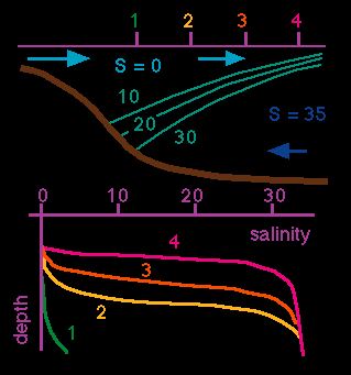 Figure 11.2
The characteristics of the salt wedge estuary are (Figure 11.2): The salinity in both layers is nearly uniform along the entire length of the estuary. Water exchange between the two layers is restricted to the frontal zone between the layers, which is governed by intense turbulence. A region of very rough (turbulent) water marks the region where the turbulent front reaches the surface. Vertical salinity profiles show oceanic salinity below the interface, fresh water conditions above the interface, and a gradual upward shift of the interface position from the estuary's head to its mouth. Observations show that considerable tidal forcing is required to produce an exchange of mass beyond the frontal zone. A tidal volume equal to the fresh water volume will still produce a salt wedge. Typical R/V ratios for salt wedge estuaries are in the range of 1 and above.
If the tidal volume is increased over R to reduce the ratio R/V to 0.1 -1, the estuary changes into a highly stratified estuary, also known as the partially mixed estuary with entrainment. The fresh water movement in the upper layer against the stronger tidal current produces strong current shear at the interface. This creates instabilities in the form of internal waves which become unstable and break. When the tops of the breaking waves separate from the interface they inject salt water into the upper layer. The result is a net upward transport of mass and salt known as entrainment. (As a general definition, entrainment is the transport of mass drawn from a less turbulent medium into a more turbulent medium. Note that entrainment is a one-way process; there is no transport of mass from the more urbulent medium to the less turbulent medium.)
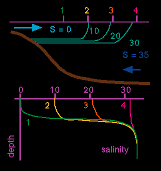 Figure 11.3
The characteristics of the highly stratified estuary are (Figure 11.3): The salinity in the upper layer increases towards the sea, on account of the addition of salt by entrainment from the lower layer. The salinity in the lower layer remains constant at the oceanic value. Vertical salinity profiles show oceanic salinity below the interface and a gradual salinity increase from station to station above the interface as the ocean is approached.
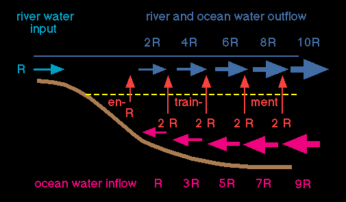 Figure 11.4
A particularly interesting aspect of the highly stratified estuary is the intensification of the circulation produced by the entrainment process. Figure 11.4 shows the principle. An amount R of fresh water enters the estuary at its head during a tidal cycle. This water moves towards the sea in the upper layer. Entrainment from below adds salt water to the layer, increasing the volume transport of the upper layer. This process continues, and the volume transported in the upper layer increases to several times the fresh water volume supplied by the river, say to nR, where n is the magnification factor for the estuary. In the lower layer, a corresponding volume (n-1)R has to be supplied to make up for the loss from entrainment into the upper layer. It is seen that the introduction of the volume R into an otherwise oceanic environment produces a vigorous circulation in which the additional volume (n-1)R is drawn from the sea into the estuary and returned after mixing with the fresh water. This illustrates the thermohaline character of the estuarine circulation quite well; without the "priming" of the system by fresh water the estuary would be nothing but an appendix to the coastal ocean with identical water mass and very little mean movement.
Because water is constantly added to the upper layer along the length of the estuary, the interface does not come up to the surface but remains submerged even at the mouth, where its location is hard to determine from the salinity profile. It is, however, well defined through the depth of zero mean flow and can thus be determined through current measurements over a tidal period if required. Observations show that magnification factors of 30 and more are easily obtained.
Highly stratified estuaries usually require a large lower layer volume in comparison to the volume of the upper layer, to provide enough oceanic water for the entrainment process. This condition is met particularly well in true fjords, where the fresh water is derived from the melting of glaciers and produces a thin upper layer that is only a few metres thick and spreads over a lower layer which may be hundreds of meters deep.
If the tidal volume is further increased to a R/V ratio of 0.005 - 0.1 the estuary turns into a slightly stratified estuary, also known as the partially mixed estuary. The tidal current is now so strong that water movement becomes turbulent everywhere. In shallow estuaries the turbulence is mainly the result of bottom friction. Current shear between the fresh water trying to make its way towards the sea and the tidal current adds to the turbulence, and the entire volume of the estuary experiences turbulent mixing. As a result, mass and salt are exchanged between the two layers in both directions.
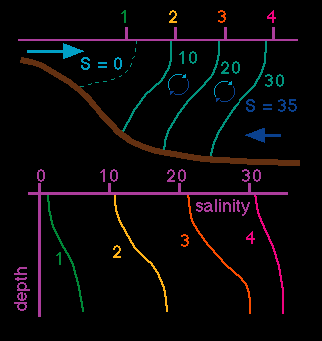 Figure 11.5
The characteristics of the slightly stratified estuary are (Figure 11.5): The salinity in the upper layer increases towards the sea, on account of the addition of salt water from the lower layer through turbulent eddies. The salinity in the lower layer decreases towards the estuary head, on account of the addition of fresh water from the upper layer through turbulent eddies. Vertical salinity profiles show a gradual salinity increase from the surface to the bottom, with a maximum in the vertical gradient near the interface between the two layers, and a gradual salinity increase from station to station at all depths as the ocean is approached.
Does the intensification of the circulation so typical for the highly stratified estuary also occur in a slightly stratified estuary? The turbulent eddies move water both upward and downward, so it might be argued that the net transport of mass between the layers could be small and that the upper layer transport could remain relatively constant. Consideration of the salinity budget quickly shows that this cannot be so. A fresh water volume R enters from the river during a tidal cycle; the same volume has to pass through every cross section along the estuary. By definition, the mean flow of the lower layer is directed into the estuary, so the volume R must pass through the upper layer. Assume now that over a certain distance from the estuary head, a volume R' is brought up from the lower layer and mixed into the upper layer, while an equal volume is mixed down from the upper into the lower layer. As a result, some of the fresh water is now found in the lower layer, where it is moved back towards the head, while the upper layer transport contains some salt water from the lower layer. In order to maintain the transport of fresh water in the upper layer at the required rate of R/T, the total transport in the layer has to increase in proportion to the increase of the mean salinity in the layer.
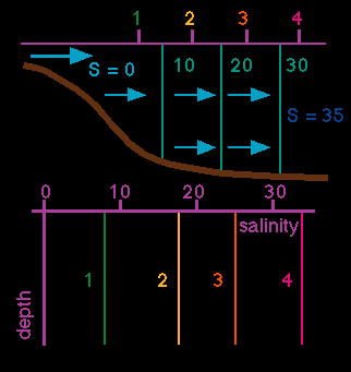 Figure 11.6
The actual rate of increase depends on the efficiency of the mixing and on the degree of local recirculation of the fresh water between the layers which determines the salinity distribution. It can therefore not be calculated in the simple way that applied to the highly stratified estuary. Chapter 14, which discusses the salt balance in detail, will address this problem further. If the tidal volume is further increased to a R/V ratio below 0.005, turbulent mixing becomes so efficient that locally all salinity differences are nearly eliminated and the estuary turns into the vertically mixed estuary (Figure 11.6). The characteristics of the vertically mixed estuary are: The salinity increases towards the sea but does not vary with depth. Vertical salinity profiles therefore show no salinity change with depth but a gradual salinity increase from station to station as the ocean is approached. The mean flow, which is very weak compared to the strong tidal current, is directed towards the sea at all depths; penetration of salt into the estuary is achieved entirely by turbulent diffusion against the mean flow. The distinction between upper and lower layer can no longer be made.
The four estuary types discussed so far cover the possible circulation schemes for positive estuaries. The discussion followed in essence the development and descriptions of Pritchard (1955), Cameron and Pritchard (1963) and Pritchard (1967), the pioneers of estuary classification. It goes without saying that real estuaries never fit the idealised classifications exactly. The vertically mixed estuary in particular is more a concept than a description of a real situation; complete vertical homogenisation of the salinity field is rarely achieved in the field. However, comparison between the circulation schemes of the slightly stratified and the vertically mixed estuary (Figs. 11.5 and 11.6) clearly shows that the transport of salt into the estuary is achieved in the two estuaries in different ways and that a theoretical model of the circulation therefore has to be formulated differently for the two cases. Theoretical analysis of estuarine circulations is beyond the scope of these notes; but we shall consider some modifications of the classification for positive estuaries towards the end of this chapter.
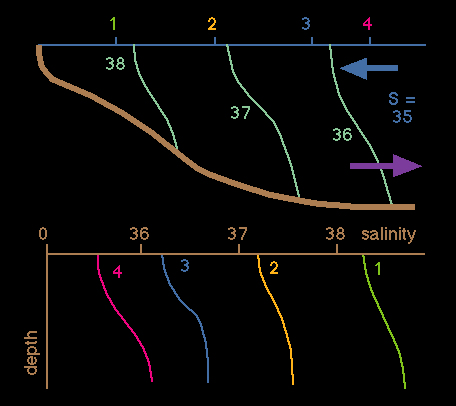 Figure 11.7
The next type of estuary to consider is the inverse estuary. It is also called the negative estuary, because it is associated with negative R/V ratios. Its circulation is best understood by assuming that there is no river input of fresh water at all and that the estuary is exposed to evaporation at its head instead, which leads to a salinity increase in the surface water at the inner end of the estuary. The associated density increase causes the water to sink and flow out towards the sea near the bottom. The result is again a two layer circulation but with reverse movement, with ocean water entering the estuary in the upper layer and hyper saline estuary water leaving in the lower layer (Figure 11.7). The same circulation is set up if the evaporation is not restricted to the inner region but acts on the entire estuary; flow into the estuary at the surface will then still produce an accumulation of the most saline water at the head, and the associated density field will maintain a pressure gradient along the estuary and drive an inverse circulation. The fresh water volume R is then given by the amount of water evaporating during a tidal cycle and considered negative because it represents a fresh water loss.
The characteristics of the inverse estuary are: The salinity in the upper layer decreases towards the sea; the salinity in the lower layer increases towards the estuary head. Vertical salinity profiles show a gradual increase from the surface to the bottom, with a maximum in the vertical gradient near the interface between the two layers, and a gradual salinity decrease from station to station at all depths as the ocean is approached.
Most estuaries experience both inflow of fresh water from rivers and fresh water loss from evaporation. In many instances the evaporation is small compared to river input and the estuary corresponds reasonably well to one of the four types of positive estuary. In arid climates evaporation can be much larger than river input, and estuaries are well described by the inverse type. The intermediate situation where the evaporation exceeds the fresh water supply from rivers only marginally, so that R/V is only just negative, is not uncommon in regions with seasonally variable rainfall in the tropics, where evaporation is permanently high, and is then observed during the dry season. The type of estuary observed in this situation has become known as the salt plug estuary.
The circulation of the salt plug estuary can best be described as a combination of a positive and a negative estuary. At its head, fresh water entering from the river moves toward the sea in the upper layer. Since the river transport is small, the upper reaches of the estuary usually resemble the slightly stratified type. As the water in the upper layer makes its way towards the sea it is exposed to strong evaporation. There comes a point where an amount equal to the amount of fresh water supplied by the river has evaporated. From this point on, further evaporation increases the salinity in the estuary beyond oceanic salinity, the estuary becomes hyper saline, and the circulation in its lower reaches is of the inverse estuary type.
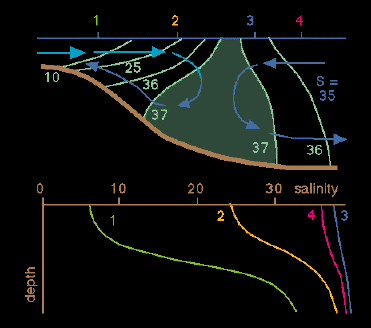 Figure 11.8
The characteristics of the salt plug estuary are (Figure 11.8): The salinity shows a maximum somewhere within the estuary at all depths (the "salt plug"). The salinity in both layers increases towards the sea on the river side of the salt plug and decreases towards the sea on the ocean side. Vertical salinity profiles show a gradual increase from the surface to the bottom, with a maximum in the vertical gradient near the interface between the two layers; horizontally, they show a gradual salinity increase from station to station at all depths on the river side of the salt plug as the ocean is approached, and a gradual salinity decrease on the seaward side of the salt plug as the ocean is approached.
The location of the salt plug depends on the ratio of fresh water supply and evaporation. It has to be within the range of tidal influence, because the establishment of a positive estuary circulation on its river side depends on the effect of tidal mixing. The plug therefore shifts up and down the estuary with the tide.
An intriguing feature of the salt plug estuary is the separation of the circulation driven by the river input of fresh water from the circulation involving exchange with the open sea. Seen from an aircraft or satellite, there is continuity of water between river and ocean and the salt plug estuary appears as a river entering the sea. In reality, nearly no water passes the salt plug, and very little river water ever reaches the sea. The mean flow goes to zero at the salinity maximum, so the only exchange of water between the two sides is achieved by turbulent diffusion. This has important consequences for the management of this type of estuary, since all material introduced into the estuary on the river side of the salt plug will accumulate in the estuary (apart from some weak diffusion through the salt plug) until the next wet season removes the plug.
From the point of view of hydrodynamics, any given two dimensional estuary can be described by one of the six estuary types discussed so far. The association of a particular estuary with a given type is not permanent, since the ratio R/V can change in time as a result of variations in rainfall over the catchment area of the rivers. The change of type depends to some degree on the size of the catchment area and its capacity to even out variations in rainfall before they reach the estuary. Variations in tidal current strength between spring and neap tide can also cause a change of classification if the difference between spring and neap tide is large. It is seen that a complete description of an estuary requires its classification for a range of environmental conditions. Chapter 13 will present some examples.
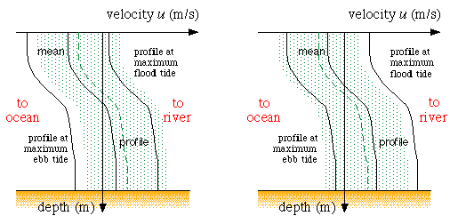 Figure 11.9
Modifications of the classification scheme are imposed if the estuary cannot be regarded strictly two dimensional. The basic classification remains the same but each type has to be subdivided into the laterally homogeneous case (identical to the two dimensional case described above) and the laterally inhomogeneous case. The latter is most easily described in terms of departures from the homogeneous case. In general, departures from two dimensionality are produced by the Coriolis force which concentrates flow on the right of the estuary in the northern hemisphere and to the left of the estuary in the southern hemisphere (looking in the direction of the flow). In the northern hemisphere this means that the flood tide flows stronger along the left bank (looking towards the sea) and the ebb tide flows stronger on the right bank. As seen from Figure 11.9 this results in weaker mean flow on the left bank and stronger mean flow on the right bank. If the effect is strong, the mean flow on the left bank can actually be directed into the estuary and produce a secondary circulation in the horizontal plane where ocean water flows into the estuary along the left bank while the fresh water leaves the estuary along the right bank (Figure 11.10).
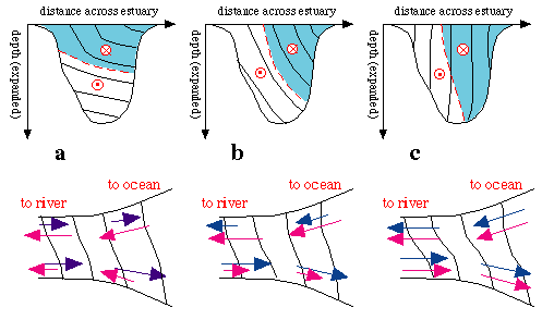 Figure 11.10
Dynamically, an estuary has to be classified laterally inhomogeneous if the lateral pressure gradients generated by lateral salinity differences play a significant part in the balance of forces. This occurs most frequently in the vertically mixed estuary (Fig. 11.10c). Its weak mean flow is easily affected by only slight salinity differences between the two banks, and the laterally homogeneous vertically mixed estuary of Fig. 11.6 may be quite rare. However, the characteristics of each estuary type sketched in Figs. 11.2 - 11.7 still apply, as long as the stations are taken along the axis or along one side of the estuary.
From the point of view of hydrodynamics, differentiation between laterally homogeneous and inhomogeneous estuaries completes the discussion of estuary classifications. Other types of estuaries occasionally found in the literature can always be grouped with one of the types discussed above. The intermittent estuary is characterised by the temporary disappearance of the thermohaline forcing and, as a consequence, changes more or less regularly from an estuary to an oceanic embayment and back. During its estuarine period it receives fresh water from land drainage. Depending on the amount of fresh water and the associated R/V ratio it is then a salt wedge, highly or slightly stratified, or vertically mixed estuary. During its oceanic period the fresh water supply dries out, and the estuarine circulation disappears (unless strong evaporation turns the estuary into the inverse type).
Dynamically, both conditions are well understood. What sets the intermittent estuary apart from all other estuary types are the consequences of the change from estuarine to oceanic for the marine ecosystem. Generally speaking, the large salinity variations found in estuaries create a demanding environment for marine life. Some plants and animals adapt to such conditions better than others. Some specialise in living in the brackish zone. Estuaries therefore have their own ecosystem, characterised by high tolerance of salinity variations and strong interactions with the adjacent marine ecosystem. Intermittent estuaries experience changes from estuarine to oceanic marine life (Cuff and Tomczak, 1983). This creates very difficult conditions for estuarine life forms, which may find it difficult to survive during oceanic periods if they cannot retreat into a nearby estuarine environment.
For completeness we mention briefly the situation where an estuary is structured by topography and it makes sense to distinguish between its different parts. Individual branches of such an estuary would then fit our definition (being narrow and having a salinity measurably different from the salinity of the open sea) except for the connection with the open ocean (because they are connected with another part of the same estuary). Such water bodies can be called sub-estuaries, and their connection with the open ocean the parent estuary. The circulation in sub-estuaries can be seen as being driven by the salinity difference between the upper and lower layers of their parent estuary, which induces two layer inflow and outflow at the sub-estuary's mouth. If the task is a study of the sub-estuary it may be appropriate to limit the observational field program to the sub-estuary and exclude its parent estuary. A dynamic model of its circulation would then have to take into account the vertical salinity gradient found at its mouth and thus would have to be formulated quite differently from the ways suggested by our estuary classifications. This is, however, only a practical consideration and does not distract from the fact the the estuary as a whole (parent estuary and all its sub-estuaries) is well described in all its parts by our classifications.