

![]()
![]()
![]()
![]()
Ocean and atmosphere form a coupled system. The coupling occurs through exchange processes at the interface (the sea surface). These exchange processes determine the energy and mass budgets of the ocean. Quantities exchanged between the ocean and the atmosphere are:
| In the energy budget: | radiative energy (including heat) momentum |
| In the mass budget: | freshwater, through - evaporation/condensation and - precipitation/river run-off minerals gases |
Gases absorb radiative energy selectively. Some gases are transparent to the short wave radiation emitted by the sun but highly absorbent at the longer (infra red) wave lengths at which the earth emits radiative energy into space. High concentration of these gases in the atmosphere leads to a trapping of radiative energy in the atmosphere which manifests itself as an increase in the atmospheric temperature. These gases are therefore known as greenhouse gases. Carbon dioxide is a particularly important greenhouse gas.
The role of the ocean in the earth's climate and its capability of storing carbon dioxide (CO2) is discussed in the following text, taken from The Ocean and Climate by R. W. Stewart (ims Newsletter 55/56 1991, Unesco, Paris). Some annotations, which are not part of the original text, were added to make the text more accessible to first year students; these annotations are in orange.
Begin of quotation
The ocean plays a role in the climate system which is complementary and of comparable importance to that of the atmosphere. It stores heat and releases it later, and often in a different place. It transports heat in amounts comparable with atmospheric transport. It both absorbs and releases carbon dioxide. (...) It is sometimes referred to as the "flywheel of the climate system" (...). Like a flywheel, the ocean stores energy, in this case thermal energy, when it is in large supply during the day or summer, and releases it when the energy supply is reduced or reversed during night or winter.
When it is heated the ocean responds by storing some of the heat and by increased evaporation. Because the heat is mixed down for some metres by the wind, temperature rises much less than it does on dry land under the same heating conditions. The evaporation has profound effects on the atmosphere and on climate. Water vapour released into the atmosphere importantly increases the greenhouse effect in the atmosphere. When it recondenses, the resulting heating of the air is a major source of energy for atmospheric motion.
When the ocean is cooled, it responds by generating vertical convective motions, which resupply heat to the surface. (This occurs because continuity of mass requires that cold water sinking from the surface is replaced by water from below. This water is - slightly - warmer than the sinking water and thus represents a supply of heat.) Thus the temperature fall is much less than over land under the same cooling conditions.
The overall result is that for the two thirds of the earth's surface covered by ice-free ocean, the temperature over the whole ocean ranges only from -2ºC (the freezing point of salt water) to 30ºC, and at any one place by hardly more than 1ºC during the course of a day and 10ºC during the course of a year. This range might be compared with that over dry mid continental areas, where the variation from place to place can be about 100ºC, and during the course of the year in particular places about 80ºC. Further, the relatively slow response of the ocean to heating and cooling results in the oceanic annual cycle being retarded relative to that in continental regions. (Much more energy is required to change the temperature of water than the temperature of air, so the ocean takes longer to heat up or cool down. As a result the ocean is still warming up in late summer when the air is still warmer then the water but already cooling, and it is still cooling down in late winter when the air is still cooler than the water but the atmosphere is already warming.)(...)
Such effects would be experienced even if the ocean were little more than a deep swamp. However, the ocean (...) moves. (...) In moving, it redistributes heat (and salt) in ways that are of central importance in determining the details of the earth's climate.
The North Atlantic provides a particularly notable example. In the tropical Atlantic, solar heating and excess evaporation over precipitation and runoff creates an upper layer of relatively warm, saline water. Some of this water flows north, through the passages between Iceland and Britain. On the way it gives up heat to the atmosphere, particularly in winter. Since winds at these latitudes are generally from the west, the heat is carried over Europe, producing the mild winters which are so characteristic of that region relative to others at similar latitudes.
So much heat is withdrawn (from the ocean and absorbed by the overlying atmosphere) that the temperature (of the water at the ocean surface) drops close to the freezing point. This water, now in the Greenland Sea, remains relatively saline, and the combination of low temperature and high salinity makes the water more dense than deeper water below it. Convection sets in and the water sinks - occasionally and locally right to the bottom. There it slides under, and mixes with, other water already close to the bottom. It spreads out and flows southward, deep and cold.
This thermohaline circulation: surface warm water flowing north, cooling, sinking and then flowing south provides an enormous northward heat flux. It amounts to 1 PW (petawatt, 1 PW = 1 billion megawatts), fully comparable with that transported poleward by the atmosphere.
(...)
Water (from all depths) is in repeated contact with the surface and comes into approximate equilibrium with atmospheric concentrations of gases, including notably O2, CO2 and freons. The freons are inert (not influenced by biological processes or chemical reactions; their concentration is only affected by the mixing of water), and provide a valuable passive tracer for ocean movement. O2 and CO2, on the other hand, are strongly affected by biological activity. The surface layers of the ocean contain planktonic plants which, in the presence of sunlight, convert dissolved CO2 into organic carbon. The plants are eaten by animals, which are in turn consumed by other organisms. Debris from these organisms falls out of the surface layers into the deeper water. On the way down, bacteria decompose some of the material, releasing CO2 and absorbing O2. As a result the deeper water is enriched in CO2 and nutrients and depleted in O2.
(...)
The ocean plays a key, but frequently understated, role in determining the earth's climate. Indeed any possibility of predicting the evolution of climate beyond a few weeks demands that ocean behaviour also be taken into account.
(...)
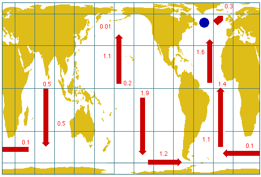 Map
Map
With respect to sensitivity to, and contribution to, long term climate change: there is every reason to believe that the ocean is now changing, in response to climate changes over the past few hundred years (the Little Ice Age). It can be expected to change further as anthropogenic influences (influences from human activity) become increasingly marked. The effect of the ocean on the atmosphere could be either to moderate or to intensify these changes. It will certainly modify them.
The map shows how the ocean circulation distributes heat throughout the world's oceans.
End of quotationThe thermohaline circulation described above ("surface warm water flowing north, cooling, sinking and then flowing south ") has become known as the Great Ocean Conveyor Belt (Figure 8.1): The water that sinks in the North Atlantic Ocean (North Atlantic Deep Water) enters the Antarctic Circumpolar Current and from there all ocean basins, where it rises slowly into the upper kilometre and returns to the North Atlantic in the permanent thermocline.
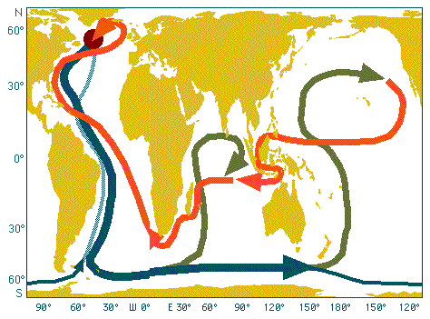 Figura 8.1
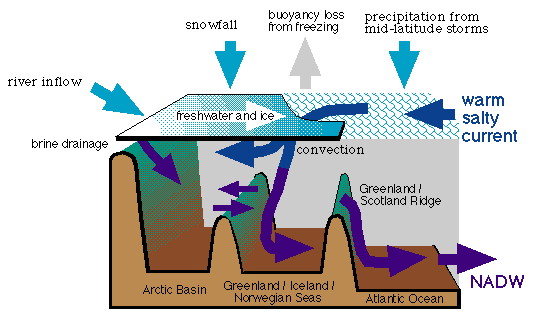 Figure 8.2
Formation of North Atlantic Deep Water does not necessarily continue forever. The deep convection in the Greenland Sea occurs in a region where cold, fresh water and warm, saline water meet (Figure 8.2). Convection occurs when the warm, salty water gets cold enough to sink, just before its relatively high density forces it to slide underneath the fresh polar surface waters and continue as a subsurface current (the "Atlantic inflow" in Figure 8.2). Convection can be inhibited by a number of processes. If the climate gets warmer, additional melting of ice will increase the volume of the Arctic outflow of cold, fresh water and push the region where the warm, salty current is forced to underneath the fresh polar surface waters further to the south. The warm, salty water is then insulated from atmospheric cooling and will no longer sink. This will stop the conveyor belt. As a result, Europe will become much colder, more ice will form in the Arctic, outflow of cold, fresh water will be reduced, and the conveyor belt will be active again. It is seen that the ocean can support two alternate circulation systems as the two states of an oscillation system. There is geological evidence that the conveyor belt is inactive during ice ages.
The question whether and to which degree the thermohaline circulation is susceptible to human activity is the subject of intense research in numerous institutions around the world.
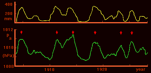 Figure 8.3
The discussion of ocean circulation changes and ice ages above gave one example of oscillatory behaviour of the coupled ocean/atmosphere system. Another example, on a time scale short enough to be experienced during a human life span, occurs in the Pacific Ocean and is known as ENSO, which stands for El Niño - Southern Oscillation. The Southern Oscillation is the term for a large-scale oscillation of air pressure observed in the tropics around the globe and particularly clearly over the tropical Pacific Ocean, where air pressure is high in Darwin when it is low in Tahiti (or the central and eastern Pacific Ocean in general) and vice versa. Figure 8.3 shows the effect of the Southern Oscillation on air pressure and rainfall. It is seen that high air pressure at Darwin is linked with high rainfall in the central Pacific.
El Niño is the name for the oceanographic side of the phenomenon. One of the richest fishing regions of the World Ocean, the South Pacific coastal upwelling region along the coast of Peru, Chile, and Ecuador, occasionally experiences an influx of nutrient-poor, warm tropical water which suppresses the upwelling of nutrients. The anchoveta which inhabit these waters in their millions forming the nutritional basis for a huge bird population and the stock for an important fish meal industry, depend on the supply of nutrients to the surface layer. They avoid the warm nutrient-poor water, which causes mass mortality amongst the birds. If the extent of the tropical influx is very severe, mass mortality can occur among the fish as well; hydrogen sulphide from decaying fish has been known to blacken the paint on ships in Callao harbour. When this occurs it occurs usually just before Christmas - thus the name "El Niño" (the child) which relates the event to the birth of Christ. The high temperatures along the South American coast last for about a year or more before conditions return to those which prevailed before the influx of tropical water.
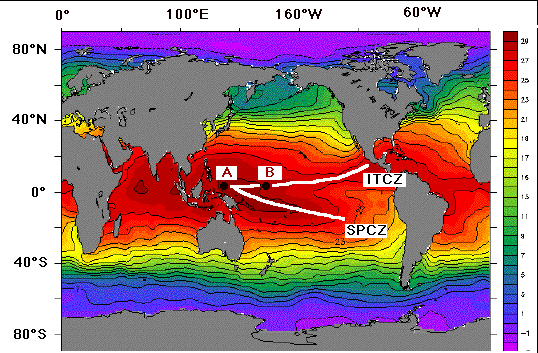 Figure 8.4
A simplified description of the mechanism how ocean and atmosphere interact to cause an ENSO events starts from the effect of sea surface temperature on winds. Figure 8.4 indicates that the two convergence zones in the atmosphere coincide with regions of high sea surface temperatures. This is because the air is heated where the water is warm; it rises, producing a convergence of the winds above the sea surface (seen in high average cloud cover, Figure 8.5) - in other words, sea surface winds blow towards regions of high sea surface temperature. This results in accumulation of warm water, which increases the heating; the air rises faster, wind speed increases - a positive feedback is established.
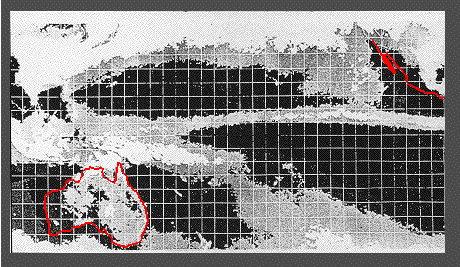 Figure 8.5
Suppose now that through some disturbance the region of highest temperature is shifted from the region where the ITCZ and the SPCZ meet (point A in Figure 8.4) to a point somewhere further east (point B). Winds continue to blow towards the highest sea surface temperature; so the winds to the west of that point will reverse their direction and change from Trades to westerlies. Again, this pattern will be reinforced through positive feedback. The centre of rainfall is shifted from A to B; drought conditions are observed in Australia. This is often accompanied by tropical cyclone development (Figure 8.6).
 Figure 8.6
The change from one state of the ocean/atmosphere feedback system to the other requires unstable conditions in the atmosphere. Such conditions occur usually around May or June when the atmospheric circulation over the adjacent Indian Ocean changes from Northeast to Southwest Monsoon. Whether an ENSO event occurs in a particular year is therefore usually decided in May.
The westerly winds in the western equatorial Pacific trigger a solitary internal wave of large scale (several hundreds of kilometers in length and about 400 km across) which travels eastward along the equator, advecting warm tropical water into the South American coastal upwelling region. The detailed dynamics are complicated and involve several types of long oceanic waves of very low frequency which take between 1 - 4 months to cross the equatorial Pacific Ocean and alter the temperature of the upper ocean thousands of miles from where they were generated. What is important in the process is that the original disturbance in the ocean/atmosphere system which occurred in the western Pacific Ocean early in the year produces a suppression of coastal upwelling and an influx of tropical water along the coast of Peru, Chile and Ecuador later in the year. The suppression of upwelling is most intense in November - December and does not disappear until well into the following year.
 Animations
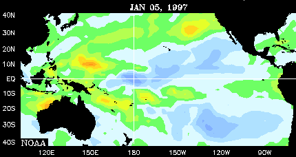
To conclude this lecture we look at the ENSO event of 1997/98. This was a particularly strong and long lasting ENSO event, not necessarily typical of others; but all ENSO event are different, and the 1997/98 El Niño was observed by satellite, so we have a particularly good data base.
Animations of sea surface temperature and rainfall information will be used to follow the evolution of the ENSO event. They will be displayed in a separate window, accompanied by further explanation. Please set the window to maximum wide enough to accommodate the animations when it appears, and close it when you are finished.
A word of warning if you are studying this chapter from the internet (and not from the CD): The animation files are nearly 1 Mb each and therefore take substantial time to load over a phone line.
The best way of studying the animation is by viewing it through QuickTime or an equivalent image player. If you do not have the QuickTime Player you can watch the animation in the browser window, but you will not be able to stop at individual frames. Choose which option you wish to use:
See the animations in the browser.
Use an image player to see the animations.