

![]()
![]()
The earth has many faces, and all are forever changing. The geological cycle of rock formation, uplift, erosion, sedimentation and deposition of new rock is beyond the time span of a human lifetime, but the evidence is everywhere, from the smallest scales of weathering to the global scale of mid-ocean ridges. Estuaries are an important element in this cycle, because much of the sediment found on the ocean floor is derived from land and reaches the ocean through rivers and their estuaries.
From the point of view of the geological cycle of rock formation and erosion there can be no doubt that land-derived material from rivers reaches the ocean. The question becomes more intriguing when we consider the process in detail. How does the sediment reach the ocean? It is true that the river water reaches the ocean without difficulty; but freshwater is less dense than sea water and flows from the estuary head to the estuary mouth in the upper layer of the circulation. Sediment is denser than freshwater and sea water and tends to sink to the bottom. If it is to be moved it has to be kept in suspension. In the river this occurs through turbulence, which lifts sediment up from the bottom in turbulent billows and allows it to move downstream for some distance before the turbulence subsides and the sediment settles again. Smaller particles will nearly always be in suspension, giving the river its distinct murky appearance.
The situation is quite different as soon as the sediment enters the estuary. The river flow is now opposed by the tide, and the tidal current takes over the role of turbulence generator. There is now a short period of time between the rising and falling tides when the flow comes to rest and the turbulence is at a minimum. This gives the heavier sediment particles a chance to settle at the bottom. As the tidal current increases again the particles are lifted into the water column again. But unlike the river water, which continues to flow through the estuary in the upper layer, the particles are now in the lower layer of the estuarine circulation where the mean water movement is from the ocean towards the head. A large part of the sediment will therefore never make it to the sea but accumulate in the estuary.
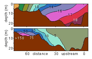 Figure 17.1
If this analysis is correct, the region where sediment accumulates should be found close to the location where the river enters the estuary and where the circulation changes from one-layer flow to two-layer flow, in other words immediately after the estuary head. Figure 17.1 shows observations from the Rappahanock estuary, one of the sub-estuaries of Chesapeake Bay on the Atlantic coast of the USA. They show an accumulation of suspended matter close to the estuary floor immediately downstream from the freshwater input, where the salinity is in the range 2 - 10. This is the typical situation for all estuaries with freshwater input. In the example of the Rappahanock estuary the sediment accumulation occurs more than 60 km upstream. In other estuaries it can occur closer to the estuary mouth, but its location always coincides with the lowest salinities (in the range 0 - 15).
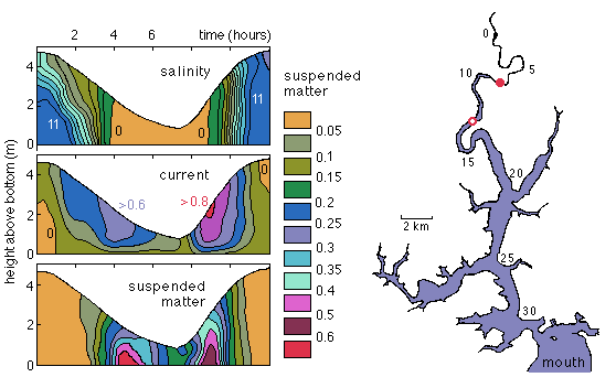 Figure 17.2
Because the sediment is kept in suspension by turbulence, its concentration in the water column varies strongly with the tide. Figure 17.2 gives an example from the Tamar River estuary in southern England. The observations were taken some 25 km upstream from the estuary mouth, where the salinity varied from freshwater at low tide to a salinity of 11 at high tide. The river discharge rate at the time was 3.5 m3 s-1 and the tidal range 3.9 m in a mean water depth of about 3 m. This makes the Tamar estuary slightly stratified and approaching a vertically mixed estuary.
The observations clearly show the shorter rising tide and the longer falling tide, and in association with this the strongest currents during the rising tide. The concentration of suspended sediment is very low at high tide and fairly low at low tide but rises rapidly as the current speed increases. Not all of the sediment concentration variability is the result of local settling and resuspension; it is possible that the sediment accumulation region is pushed upstream past the observation point as the salinity increases beyond 11. Note however, that the maximum sediment concentration is slightly higher during ebb tide than during flood tide. This suggests that not all sediment returns to the observation point with the rising tide; a small fraction appears to be able to progress towards the estuary mouth.
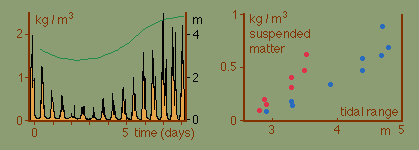 Figure 17.3
The important role of the tidal current in keeping the sediment in suspension is demonstrated in Figure 17.3, which shows observations from the Tamar River estuary taken over 8 days every 5 minutes at 0.25 m above the bottom. The maximum sediment concentration varies from neap tide to spring tide by an order of magnitude.
The right panel in Figure 17.3 shows the variation of the time-averaged suspended matter concentration with tidal range. There is a clear difference in the relationship between the situation observed when the tidal range grows from neap to spring (blue data points) and the situation when the tidal range decreases from spring to neap (red data points). Low tidal currents during neap tide allow a large fraction of the sediment to settle on the bottom. As the tidal range grows, more and more of the settled sediment returns into suspension. Lifting of settled sediment requires a higher velocity than keeping it in suspension, so the increase in the concentration from one tide to the next is slow. When the spring tide is reached and the tidal range starts to decrease much sediment is still in near-permanent suspension, and the concentration falls only slowly. As a result the sediment concentration is higher for the same tidal range during the period from spring to neap (red points) than during the period from neap to spring (blue points).
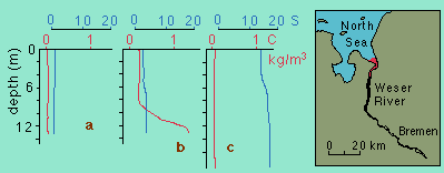 Figure 17.4
The river discharge rate has of course also a large influence on the amount of sediment that is kept in suspension at any location. Figure 17.4 shows observations from the Weser River estuary in Germany. The discharge rate of the Weser River varies greatly over a year but a typical rate is in the vicinity of 200 m3 s-1. The mean tidal range is 3.8 m and the mean water depth in the range 9 - 15 m. Because the river discharge rate is high the sediment accumulation occurs in a "turbidity region" close to the sea. Upstream and downstream from the turbidity region the suspended matter concentration does not exceed 0.05 kg m-3. In the turbidity region we find the situation already seen in the Rappahanock and Tamar estuaries: high concentrations of suspended matter in the lower layer and a salinity of 2 - 5.
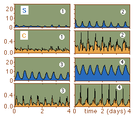 Figure 17.5
One effect of variable river discharge is that the turbidity region moves up and down the estuary in response to a decrease or increase of river flow. If measurements are made at a fixed location in the mean location of the turbidity region for several years the data will thus reveal the dynamics of the sediment movement over a large range of conditions. The observations shown in Figure 17.5 from the Weser River estuary were made with a sampling rate of 10 minutes at 1 m above the bottom. The tidal current at the site reaches about 0.5 m s-1 during flood tide and slightly less during ebb tide, and this current regime does not change significantly over a wide range of river discharge rates.
The figure shows four situations. The first example represents a river flood. The discharge rate is more than five times the average, and the turbidity region is pushed downstream. The salinity does not exceed 2.5 at all times, and the sediment concentration shows little variation over time. The low concentration values are indicative for the sediment load carried by the river before it enters the estuarine zone.
The second example shows the situation at half the discharge rate that prevailed during the flood situation (which is still about three times the average discharge rate). The salinity now varies between less than 1 and about 8 with a distinctly peaked time function, indicating that the observation station is in riverine environment for most of the time. This is supported by the low sediment concentration during most of the time. The increase in the salinity indicates the arrival of the turbidity region with the rising tide, which is clearly seen in the brief periods of very high sediment concentration.
The situation of average discharge conditions is seen in the third example. The salinity now varies in very regular fashion between 2 and 10. The sediment concentration varies with the tide. The difference in the peak concentrations between this situation and the previous and following example is most likely due to different phases in the spring-neap cycle which, as we have seen, influences the concentration levels.
The final example shows the situation during periods of unusually low river discharge. The turbidity region has moved further up the estuary, and the station is now located in fully estuarine conditions throughout, with salinities varying between 7 and 16. The sediment concentration remains low but varies with the tide and displays a sharp rise at low water, indicating that the turbidity region just reaches the location of the measurements then.
The accumulation of large amounts of sediment in a 20 km long section of an estuary can cause a significant problem for shipping if ocean going vessels are to reach ports further upstream. The former major port on the Weser River, Bremen, is located 60 km upstream of the turbidity region. To maintain access to the port of Bremen for ocean-going vessels the port authority has to operate a continuous dredging program.
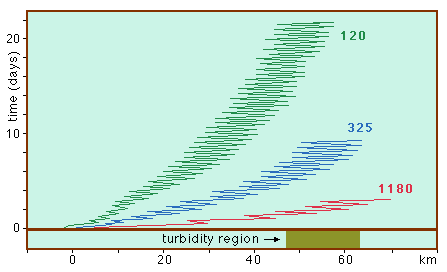 Figure 17.6
How does the sediment eventually leave the estuary? The key factor is the river discharge. High river run-off pushes the turbidity region further downstream, and the higher level of turbulence associated with the increase in the mean flow keeps the sediment longer in suspension. This allows the sediment to propagate through the turbidity region without being trapped. Figure 17.6 shows the results of a numerical model simulation of particle movement through the Weser River estuary under different discharge rates. Under conditions of low to medium discharge rates the particle approaches the turbidity region but then remains in it for weeks, moving back and forth with the tide. Under river flood conditions the particle traverses the estuary in a few tidal cycles.
The model result shows the importance of flood events for the flushing of sediment from estuaries. In many regions river floods are an annual event, so the estuaries are freed from much of their sediment load once every year. Salt plug estuaries, for example, accumulate sediment and organic matter upstream from the salt plug, and this material cannot leave the estuary while the salt plug exists. As the monsoon rains set in the river discharge increases, and the salt plug is removed, allowing the accumulated sediment to be flushed into the sea.
River floods are not always benign and can wreck havoc on low lying areas if the river discharges too much water in a short time. Government authorities often try to contain discharge rates within narrow limits by storing flood waters in retaining basins behind dams or artificial lakes and releasing the water during periods of low river flow. This comes at the cost of reducing the estuary's capacity of flushing its accumulated sediment load and can result in a need for more frequent dredging if a shipping channel has to be maintained in the estuary.