

![]()
![]()
The last two chapters introduced classification concepts for estuaries derived from physical principles of fluid dynamics. This chapter presents observations from real estuaries for the various classifications.
An unparalleled example of a salt wedge estuary is the Mississippi River. Its majestic size allows the documentation of details in the estuarine structure that would be difficult to observe in estuaries of more common size. With a transport of some 16,000 m3 s-1 the Mississippi River is the third largest of all rivers of the world (after the Amazon River with a transport of 175,000 m3 s-1 (or in oceanographic units 0.175 Sv) and the Congo River with 38,000 m3 s-1), and its freshwater supply to the ocean is comparable to the transport of many ocean currents.
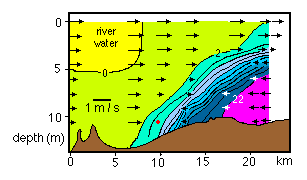 Figure 13.1
Figure 13.1 is a section along the estuary axis containing the interface between the upper and lower layer. Currents observed by lowering a current meter from a vessel are superimposed on the observed salinity field. The separation between freshwater outflow in the upper layer and salt water inflow in the wedge is clearly visible. Note in particular the change in current direction in the mixing region along the interface; it indicates that water from both layers is drawn into the mixing region and transported towards the ocean in the mixing zone. The slight velocity increase in the upper layer above the salt wedge is more the result of a decrease in layer depth than an indication of an increase in layer transport.
The Mississippi River is a particularly good example of a salt wedge estuary, since its size allows the detailed observation of the current field even in the narrow interface between the salt wedge and the freshwater layer. In comparison, outflow from the Amazon River, the largest estuarine system of the world, is so huge that it distorts the salt wedge structure significantly. The Amazon River carries about 20% of the world's river run-off. The shear magnitude of this freshwater outflow guarantees that no salt water ever penetrates past the river mouth, even though the influence of the ocean tides extends 735 km upstream.
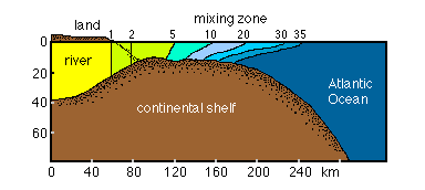 Figure 13.2
The interface between the freshwater and the ocean water takes the shape of a mixing region on the shelf outside the estuary. Its extreme width of 150 km (Figure 13.2) makes it difficult to recognize that the Amazon River is a salt wedge estuary, which it is, on account of its extreme R/V ratio. Its character as a salt wedge estuary is revealed when the physics of the circulation is considered: Freshwater is drawn into the mixing region from the river side, where all mean flow is towards the sea; salt water enters the mixing region from the ocean. All mixing occurs in the region between the two sides, and the brackish mixing product is moved upward and outward towards the ocean, where it produces permanently agitated, choppy and bubbly seas that can on occasions become dangerous for small craft.
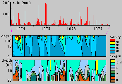 Figure 13.3
The examples from two of the mightiest rivers of the world should of course not distract from the fact that the classification of estuaries is independent of size and only determined through their R/V ratio. To demonstrate this for the case of the salt wedge estuary Figure 13.3 shows salinity against time from one station in South West Arm of Port Hacking, a small estuary on the east Australian coast in the southern suburbs of Sydney. This estuary is characterized by moderate tides. Its South West Arm is only 3 km long and receives freshwater input from a small 4 km long creek. During periods of heavy rain the creek is in full flood and its water flows out into South West Arm with little mixing from the tide. The salinity distribution then shows a well defined salt wedge with a thin mixing zone below the outflowing freshwater. The figure shows the rapid development of the mixing zone with every major rainfall period.
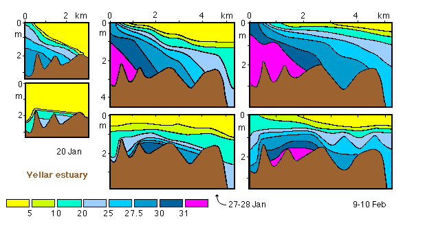 Figure 13.4
As a last example of a salt wedge estuary we consider a medium sized, shallow tropical estuary. The Vellar estuary on the eastern coast of southern India is less than 20 km long, about 300 m wide in its lower reaches and on average only 1.5 m deep. The mean tidal range is about 0.7 m. Figure 13.4 shows salinity sections along the outermost 5 km of the estuary for a 3 week period. Heavy rain occurred before the observations; river run-off on 20 January was still 375 m3 s-1. The salt wedge structure that exists under these conditions is seen particularly well at low water, when the upper layer is virtually fresh while water with a salinity in excess of 20 is found under a thin mixing zone. The rising tide pushes the upper layer back into the estuary, causing the mixing zone to become more inclined and somewhat wider. A week later the freshwater supply is reduced to less than 100 m3 s-1, and the mixing zone expands vertically, changing the estuary into a highly stratified state.
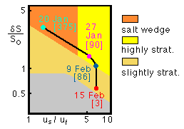 Figure 13.5
Towards the end of the observation period the salinity in the entire section changes continuously between surface and bottom; the estuary is in transition to a slightly stratified situation. These changes come out clearly in the two dimensional classification diagram, which shows how the Vellar estuary goes through the succession salt wedge - highly stratified - slightly stratified as the freshwater input decreases (Figure 13.5). This demonstrates that estuaries can change classification and that a complete description has to embrace the entire range of possible freshwater supply conditions.
The Vellar River already provided a first example of a highly stratified estuary during times of receding freshwater input. Another important group of highly stratified estuaries is presented by fjords. Most fjords receive freshwater run-off only during spring and summer when melting snow and ice enter through small rivers. Their usually great depth provides an unlimited reservoir lower layer of oceanic salinity.
Silver Bay in Canada is 8 km long, about 1 km wide and on average 80 m deep with a mean tidal range of 2 m, which gives a tidal velocity of about 0.02 m s-1. Freshwater input during late spring and summer is close to 100 m3 s-1 but less than 5 m3 s-1 during winter. This produces an upper layer of about 5 m thickness during summer, with outflow velocities of 0.15 - 0.20 m s-1. Inflow occurs over the depth range 5 - 30 m, with little movement below that depth. The salinity in the upper layer varies from zero at the head to 28 at the mouth. During winter outflow occurs with velocities of 0.10 m s-1 or less, since freshwater input is greatly reduced, but is spread over a larger depth range (about 30 m).
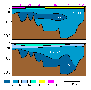 Figure 13.6
A similar situation is seen in the Hardanger Fjord, a 100 km long and over 850 m deep fjord in Norway. Its freshwater supply varies from 350 - 400 m3 s-1 in summer to less than 20 m3 s-1 in late winter. Figure 13.6 shows the salinity field for both seasons and shows that during summer the upper layer is about 50 m thick, while the inflowing oceanic water spreads in a lower layer at 200 - 300 m depth, slightly below the fjord's sill depth of about 150 m. Surface salinities vary from fresh at the head to about 31 over the sill. A sharp interface exists between the two layers. During winter the interface expands in depth due to the reduced freshwater flow in the upper layer, which gives turbulent diffusion more time to reduce the salinity gradient between the layers. Surface salinity is then nearly uniform near 33.5, but a vertical salinity profile still shows the lower layer's uniform salinity characteristic for a highly stratified estuary.
The contribution of temperature to water column stability can usually be neglected in esutaries. It is true that in shallow water temperature undergoes a larger seasonal change than salinity; but vertical temperature gradients are seldom significant and do not control the dynamics of estuaries. The Hardanger Fjord can serve as an example. Its temperature varies by 4ºC between surface and bottom during summer. This temperature gradient contributes to water column stability, but its effect is less than 10% of the contribution from the salinity gradient. During winter the fjord shows nearly uniform temperature, so vertical stability is still controlled by salinity, even though the salinity gradient is greatly reduced.
Estuaries in other climate zones show a larger annual temperature range but a similarly low contribution of temperature to water column stability. Exceptions can occur where an estuary is used to supply cooling water for a popwer station and receives waste heat from the plant. In most natural environments the temperature field is of secondary importance for estuarine dynamics.
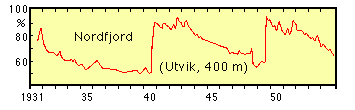 Figure 13.7
The vertical extent of the estuarine circulation in fjords is determined by the sill depth. As a consequence, the intensification of the circulation typical for highly stratified estuaries does not reach into the deep basins. For the Hardanger Fjord this can be seen from the salinity field (Figure 13.6) which shows an intermediate salinity maximum at 200 - 300 m indicative of oceanic inflow. Fjords are very similar to mediterranean seas of the dilution basin type in that respect; they can reach the same low oxygen levels or complete de-oxygenation that are observed in the Black and Baltic Seas. Figure 13.7 shows oxygen in the innermost basin of the Nordfjord, a Norwegian fjord system of interconnected deep basins, for a 24 year period. In this system, renewal of deep water occurs during periods of large freshwater run-off. The run-off stimulates the circulation and brings large amounts of oceanic water into the fjord. If this water is denser than the oldest water in the estuary, some of it fills the deep basins. The figure demonstrates that during most years the effect is not strong enough to reach the innermost basin, where deep water renewal occurred only during 1940 - 1942 and during 1949 - 1951.
The possibility for oxygen depletion exists in all estuaries with shallow sills and relatively weak tidal mixing. South West Arm of Port Hacking (Figure 13.3) is an example of a different situation. This intermittent estuary experiences moderate tides, and tidal mixing inhibits oxygen depletion during periods of little or no freshwater run-off. Increased water column stability during the periods when the estuary becomes highly stratified reduces the circulation below the sill depth and can then lead to oxygen depletion.
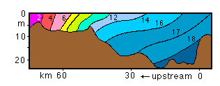 Figure 13.8
Examples of slightly stratified estuaries are abundant in the literature. Chesapeake Bay on the Atlantic coast of the USA is particularly well documented. Fed by the Susquehanna River and over 300 km long, it contains several major sub-estuaries with their own freshwater supply. Figure 13.8 gives salinity sections along the main axis of the bay. The major characteristic of the slightly stratified estuary, that the salinity varies along the estuary at any depth, comes out clearly: At 15 m depth the salinity increases from 15 to 18 over a distance of about 35 km. At the surface the salinity varies from 12 to 17 over the same distance.
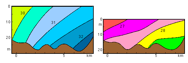 Figure 13.9
Another slightly statified estuary that has been studied for many years is the Mersey River in northern England. The river widens near the city of Liverpool but connects with the Irish Sea through a narrow passage of 8 km length and 1 - 2 km width known as the Mersey Narrows. Figure 13.9 shows salinity in the Narrows at high and low tide. The Irish Sea has significant tides, and the tidal range in the 20 m deep Mersey Narrows regularly exceeds 5 m and reaches 9.4 m at spring tide. The average river discharge rate of 25 m3 s-1 is small compared to the tidal volume of more than 200 m3 s-1. As a result the estuarine water body moves in and out with the tide over several km, and there is no overlap between the salinity range observed at high tide and the salinity range at low tide. Isohalines are slanted from surface to bottom, as is typical for a slightly stratified estuary.
The vertically mixed estuary in its pure form is rarely found in nature, but numerous estuaries can approach the vertically mixed state under conditions of low R/V numbers during spring tide or - more frequently - during periods of very low river run-off. Very large tidal range is required to produce vertically mixed conditions if the estuary receives significant freshwater input. The Bay of Fundy with its enormous tidal range of 14 m is an example of this situation (Figure 12.3).
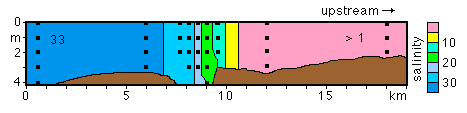 Figure 13.10
An example on a much smaller scale is the Myall River in New South Wales, Australia. The Myall River is a small river with a very small catchment area. Before discharging its very small run-off into the sea the river forms a system of lakes. It continues from the lakes to the ocean as a shallow and extremely narrow channel of about 20 km length. The average depth of this part of the river is between 2 and 4 m, and its width is less than 100 m. The river mouth is located in an oceanic bay, which reduces the impact of the moderate tides on the river; but tidal mixing in the shallow, narrow channel is nevertheless quite vigorous as the water is moved in and out of the lake in piston-like fashion, and the small river run-off is insignificant compared to the tidal volume. Figure 13.10 shows a salinity section along the part of the channel where the mixing occurs. There is virtually no vertical salinity gradient in the narrow mixing zone.
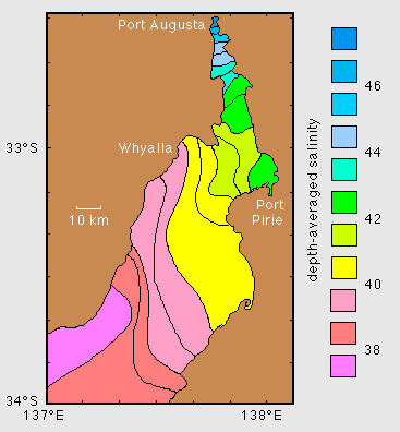 Figure 13.11
Inverse estuaries are a feature of hot arid climates. They include shallow regions with a large surface area such as hypersaline lagoons, but also gulfs of significant depth and extent. The gulfs of South Australia are typical examples. South Australia has a "mediterranean" climate with mild wet winters but hot dry summers. The gulfs are surrounded by desert-type country, where all creeks and rivers dry up during the summer. Evaporation then becomes a dominant factor in the salt budget of the gulfs, and the salinity increases from the mouth to the head. Figure 13.11 shows the salinity distribution in Spencer Gulf. It indicates that in the wider part of the gulf south of Whyalla and Port Pirie the circulation is modified by the Coriolis force, which deflects currents to the left in the southern hemisphere. Inflow of oceanic water thus occurs preferentially on the western side of the gulf, while the outflow of the salty water (which is strongest at depth) is reflected by the higher salinities on the eastern side.
The example of Spencer Gulf as an inverse estuary completes the review of all "classical" estuary classifications. Some estuaries do not fit into any of these classes but can be seen as hybrids between more than one classification. The intermittent estuary was already discussed as such in Chapter 11; South West Arm of Port Hacking is an example (Figure 13.3). The salt-plug estuary is another hybrid type estuary.
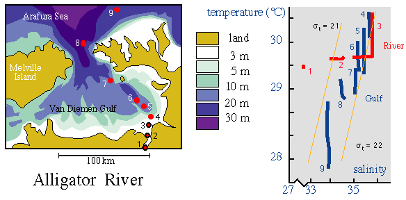 Figure 13.12
The salt-plug estuary was already introduced and briefly discussed in Chapter 11. The Alligator River in the Northern Territory of Australia is an example. Figure 13.12 shows its hydrography in a temperature-salinity diagram. The estuary is an example for a situation where the temperature stratification is significant for the stability of the water column: the Van Diemen Gulf is an inverse estuary with vertically uniform salinity. Its weak vertical density gradient is established by a warming of the upper few metres of the water column.
Some large estuaries can reasonably be divided into different parts, particularly if long narrow arms branch off the main estuary and have their own freshwater supply. If a particular part of an estuary system can be identified or described as an estuarine system of its own it is called a sub-estuary. The major difference between an estuary proper and a sub-estuary is found in the conditions at the estuary mouth. A true estuary is connected to the ocean; its salinity therefore always reaches oceanic values at the mouth, and there is no vertical salinity gradient of any importance there. A sub-estuary connects to the main (parent) estuary, where the salinity can (and mostly does) vary significantly with depth. This produces rather unique circulation patterns. Baltimore Harbour, a sub-estuary of Chesapeake Bay, provides an example (Figure 13.13).
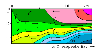 Figure 13.13
Baltimore Harbour is about 15 km long. The salinity at its mouth displays the vertical salinity structure of Chesapeake Bay at the point where it connects with its parent estuary. The sub-estuary does not have any freshwater input of importance but is exposed to tidal inflow and outflow. In an estuary proper this would result in a slightly stratified or even vertically mixed estuary; but in the sub-estuary the circulation is quite different: the salinity stratification that exists at the mouth is gradually eroded by tidal mixing, and very little stratification is found at the inner end of the sub-estuary. The resulting density distribution establishes a pressure gradient (from high density to low density) which is directed inward at the top and at the bottom, while no horizontal density gradient is experienced at intermediate depth. This drives inflow of water from the parent estuary at the top and at the bottom. Compensating outflow has to occur at intermediate depth. Baltimore Harbour thus displays a three-layered circulation system.
Other sub-estuaries show variations of this scheme, with three-layer circulation sometimes only in the outer part of the sub-estuary. The possibilities for variations are many, but all are determined by the conditions found at the juncture between the sub-estuary and its parent estuary.