

![]()
![]()
One of the factors which make the dynamics of the coastal ocean more complicated than the dynamics of the deep ocean is the frequent occurrence of fronts, ie regions with enhanced horizontal gradients of hydrographic properties. Frontal dynamics in shallow water are often nonlinear, which makes the quantitative study of frontal behaviour a difficult task. Understanding the formation, movement and persistence of frontal systems is important for many practical uses of the coastal seas. This chapter discusses the different types of fronts that occur in shallow seas and estuaries, using the approach already known from previous chapters: Reference is made to the principles of geophysical fluid dynamics where necessary but the presentation remains as elementary as possible.
Fronts in the ocean or in the atmosphere can be defined as regions where properties change markedly over a relatively short distance. How short this distance is depends on the scale of the process responsible for the front's existence. Fronts in the deep ocean can reach 100 km in width; fronts in estuaries may be only a few meters wide. What both have in common is the fact that the change of some hydrographic property - temperature, salinity or both - across the width of the front is an order of magnitude larger than changes of the same property over the same distance on either side of the front. Another way of expressing this is that fronts are regions where the horizontal gradient of a property goes through a maximum.
We met an example of a front during the discussion of coastal upwelling on Chapter 6. The front associated with the coastal jet is produced by the surfacing of the thermocline under the action of the wind. The thermocline is the region where the vertical property gradients show a maximum. Under upwelling conditions the orientation of the thermocline departs from the horizontal, resulting in a region of strong horizontal gradients. A front is formed where this region breaks the surface.
Like boundary layers and island wakes, fronts are expressions of a dynamic equilibrium established by a balance between two or more forces. They can therefore be classified according to the forces involved in the balance. Such a classification can guide our understanding of frontal dynamics, by helping us to concentrate on the essential aspects of the particular balance. Six types of fronts are usually distinguished in oceanography. Three of these are found in the coastal ocean, two in estuaries; all are discussed in detail on the following pages. The sixth type of front is restricted to the deep ocean. It is mentioned here for completeness but not considered in depth.
Before entering a discussion of differences between various types of fronts it is useful to recall some common features. To begin with, fluids and gases show a tendency to avoid strong gradients of properties and to eliminate them where they occur through turbulent mixing. The existence of fronts as quasi-permanent features of the circulation implies that they are maintained by a process that is either not present or of no importance elsewhere in the ocean. By their very nature, fronts are associated with convergent flow, which brings fluid of different properties into the frontal region. If, for example, the front is the boundary between cold and warm water, flow convergence advects cold water from the cold side and warm water from the warm side. The resulting increase in the thermal gradient across the front is large enough to overcome the effect of mixing and maintains the front. To put the argument succinctly, where there is convergence there will be a front, and where there is a front there has to be flow convergence.
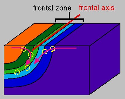 Figure 9.1
The second aspect common to all fronts follows from the first. Flow convergence into a region of strong horizontal gradients of hydrographic properties such as, for example, temperature means significant water movement across isotherms (Figure 9.1). Flow across isotherms is impossible without diffusion of heat, which counteracts the effect of advection. Fronts are therefore regions of intense turbulent mixing of momentum and other properties. This is not always appreciated without a moment of reflection. Where a front is found between two water bodies of relatively uniform properties it might appear that mixing must be strong in the two bodies of water, since they are so "well mixed", while the front displays so strong property gradients that mixing its water should be difficult. The opposite is true. Regions with small property gradients usually show low mixing activity, to the degree that water movement nearly follows the isotherms, isohalines or other property contours, while in the front mixing is vigorous and water movement is across isotherms or isohalines.
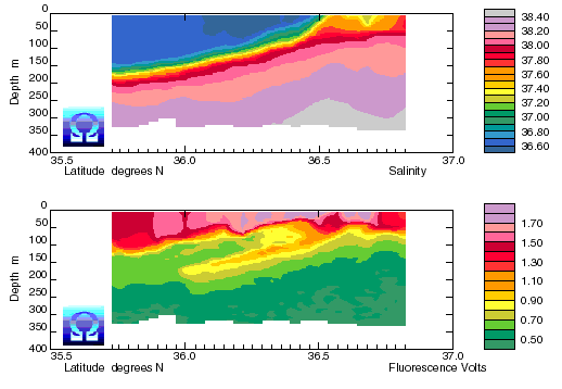 Figure 9.2
Because temperature and salinity, the most frequently measured hydrographic properties, determine the stability of the water column they are not good indicators for vertical water movement. Downward movement in the frontal zone is, however, clearly seen in optical properties. Figure 9.2 demonstrates this with observations of fluorescence in a frontal region of the western Mediterranean Sea.
Managing the coastal ocean requires an understanding of frontal dynamics for various reasons. Floating material accumulates in fronts, a result of the flow convergence at the surface. This is an important consideration in strategies to combat pollution from oil spills, since the oil will be trapped in the front. Search and rescue operations have to account for the presence of fronts, since a drifting stricken small craft will remain in a front even when exposed to considerable wind, particularly when it is partly filled with water and nearly completely submerged. Detritus and particulate matter also accumulates in fronts, and if pollutants such as heavy metals can attach to this material, their concentration will be higher in fronts than in the surrounding sea, often by orders of magnitude. The same effect is responsible for the concentration of nutrients in frontal regions, which can form the basis for increased primary production and makes larger fronts in particular attractive feeding grounds for fish. Tuna are among the species which tend to congregate in frontal regions, and the tuna fishery regularly uses satellite derived sea surface temperature maps to identify potential fishing grounds.
As already indicated, five of the six types of fronts found in the world ocean occur in the coastal ocean and its estuaries. A sixth type of front, often referred to as planetary front, is found in the deep ocean. A brief discussion of its characteristics is included here for completeness. It is not intended to be exhaustive but concentrates on aspects also found in front in shallow water.
As their name indicates, planetary fronts are of planetary scale; they span the width of entire ocean basins. They are usually associated with features of the planetary wind system. A typical example is the Subtropical Front which is formed by convergence in the Ekman layer. Other planetary fronts are found in the Circumpolar Current and between the subtropical and subpolar oceanic gyres of the northern hemisphere. These and other planetary fronts are discussed in detail in Tomczak and Godfrey, 1994.
Planetary fronts have a marked impact on air/sea interaction processes. The exchange of heat between ocean and atmosphere and the rate of evaporation depend strongly on the temperature difference between air and water. A temperature difference across a planetary front of several degrees produces very different atmospheric conditions on either side of it, which in turn may modify the conditions responsible for its formation and maintenance. Fronts of planetary scale are therefore important elements of the coupled system the ocean forms with the atmosphere. In comparison, fronts in the coastal ocean are generally smaller in extent and often less permanent in existence than fronts of planetary scale, so their influence on the atmospheric circulation is more localized.
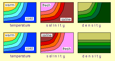 Figure 9.3
Dynamically, fronts in the ocean can be classified by their effect on the distribution of density. Sea water density is a function of temperature and salinity, and any front associated with a change of one or both of these properties across the frontal zone can affect the density distribution. If the horizontal density gradient shows a maximum in the frontal zone we call the front a density front (Figure 9.3 top). If, on the other hand, the change of salinity across the front is such that its effect on density compensates the change in temperature, the front is density-compensated; it exists then only as a temperature front and a salinity front but cannot be seen in the density field (Figure 9.3 bottom).
In the atmosphere, the density determining properties are temperature and humidity (atmospheric moisture content). With the exception of a narrow tropical region near the equator, the effect of moisture content on density is very small and can be ignored. Even in the tropics the variation of moisture content is never large enough to compensate for variations in temperature. Atmospheric fronts are therefore invariably density fronts produced by changes in temperature. Since in our daily lives we are more familiar with atmospheric than with oceanic circulation systems, it is instructive to recall what happens during the passage of an atmospheric front.
The most noticeable changes during the passage of an atmospheric front are a temporary increase in wind speed and gustiness and a change of wind direction. The increase in wind speed indicates geostrophic adjustment to the large density gradient in the frontal zone. Geostrophic wind or current velocity is proportional to the horizontal distance between isopycnals, so atmospheric fronts are always associated with strong winds blowing along the front, ie in the direction of the frontal axis. The region of enhanced wind velocity corresponds to the region of the frontal zone, so the geostrophic wind has the characteristics of a narrow jet. The change of wind direction is a consequence of surface convergence in the frontal zone, which produces a wind component directed into the frontal zone. This component changes by 180º during the passage of the front; but being superimposed on the strong geostrophic flow along the frontal axis, its net effect is a shift in wind direction of usually 90º or so as the front passes. Finally, the increase in wind gustiness indicates increased levels of turbulence in the geostrophic jet, a result of flow instability that leads to eddy formation.
The description of a density front in the atmosphere gives an equally good picture of a density front in the ocean if we replace the words "wind" and "blowing" by "currents" and "flowing". We then find that currents in a density front flow as a narrow geostrophic jet in the direction of the frontal axis, have a significant ageostrophic component of flow convergence into the frontal zone and are associated with strong eddy activity. The details of eddy formation in jets do not concern us here; they can be found in Tomczak and Godfrey, 1994).
Density-compensated fronts do not exist in the atmosphere, so we cannot draw on daily experience for their description. We can, however, use the density front as a starting point and see what changes if the horizontal density gradient is eliminated from the picture. An obvious difference is the absence of the jet in the frontal zone. Water movement in density fronts is determined by the density structure in the frontal zone, which dominates the regional circulation, to the degree that most of the transport in the entire region occurs in the frontal zone (the Circumpolar Current is an eminent example, see Tomczak and Godfrey, 1994). In contrast, water movement in density-compensated fronts is determined by the regional circulation and blends in with its surroundings. The only contribution to the mean circulation comes from the convergence associated with the front; it produces movement into the frontal zone.
The major feature of density-compensated fronts is their high degree of interleaving and the frequency of intrusions. To understand this, recall that when water moves it prefers to stay on a level where it is surrounded by water of its own density, ie it moves preferentially on its own isopycnal surface. To move a water parcel away from its isopycnal surface requires work against buoyancy. To make the parcel stay on the new isopycnal surface requires a change of its density through mixing. Movement across isopycnal surfaces is thus far more energy demanding than movement on isopycnal surfaces. In a density front movement on isopycnal surfaces produces downwelling in the frontal zone but it cannot achieve transport of water across the frontal zone. The absence of a horizontal density gradient in density-compensated fronts makes it relatively easy to move parcels of water from one side of the front to the other, since no work has to be done against buoyancy to achieve this. Sections of hydrographic properties across density-compensated fronts therefore often show a multitude of layers, intrusions, separated parcels and lenses, and the impression of a front is only gained if the view encompasses a larger region than the frontal zone itself and allows us to see the larger picture.
In summary, density fronts are associated with strong geostrophic jet-like movement of water along the front and eddy formation. Density-compensated fronts are not associated with enhanced flow along the front; they are characterized by strong layering and intrusions. Both kinds of front are found in the coastal ocean, although the distinction is not always as clear as it appeared in this discussion. The salinity gradient across a front may compensate the density effect of the temperature gradient only partially, and the degree of compensation may even change with the seasons. The character of the front will then change accordingly. The foregoing discussion can serve as a guide for the frontal features we can expect during any given season.
We begin our discussion of fronts in the coastal ocean with the upwelling front, an elementary ingredient of coastal upwelling systems discussed already in Chapter 6. The upwelling front forms when the thermocline breaks the surface as a result of upward water movement in the coastal boundary layer (see Figure 6.1). It is embedded in the general offshore movement of the Ekman layer, and its location on the shelf follows the strengthening and weakening of the upwelling circulation. The strength of the upwelling is determined by the strength and direction of the wind. Most important upwelling regions are located in the Trade Wind region where winds are relatively uniform in strength and direction. But the atmospheric circulation contains instabilities, depressions which bring a temporary increase in wind speed as they pass through. These depressions are most prominent in the wind systems of temperate regions but exist in the Trade Wind region as well. They cause periods of intense upwelling, so-called upwelling events, which alternate with periods of weak upwelling.
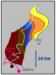 Figure 9.4
The duration of an upwelling event and the following lull in the upwelling is typically one or two weeks. This cycle dominates the movement of the upwelling front, which is seen to move in and out from the coast with the same period. In a way the upwelling front is the most visible expression of variability in the upwelling system, since it is constantly shifting its position in response to the wind. Like all other fronts it is associated with a surface convergence, which causes surface water to sink in the frontal zone. This was clearly borne out during an experiment to study primary productivity in the Canary Current upwelling region, in which a drifting buoy was used to follow freshly upwelled water. The buoy invariably drifted towards the front, reached it within a matter of a few days and then stayed in it (Figure 9.4). The upwelling front therefore constitutes the seaward limit of the active upwelling region. The presence of this surface convergence on the outer shelf is important for the upwelling ecosystem since it prevents passive substances such as phytoplankton from drifting out to sea and keeps it in the region of high primary production on the shelf. Slow swimmers such as zooplankton also find assistance in their attempts to stay within the region of high productivity.
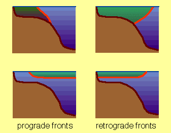 Figure 9.5
Density fronts in the coastal ocean are sometimes distinguished according to the slope of their isopycnals. A density front in which the isopycnals slope upward towards the coast is known as prograde; a density front in which the isopycnals slope downward towards the coast is called retrograde (Figure 9.5). In a prograde situation the shelf water is denser than the water on the seaward side of the front; in a retrograde situation it is less dense. Upwelling fronts are always prograde fronts.
Shelf break fronts are the result of differences in hydrographic properties between the coastal ocean and the open sea. As noted briefly in the Introduction (Chapter 1), the ocean's response to atmospheric forcing is modified in the coastal ocean through limited water depth and freshwater input from point sources along the coast. The water of the coastal ocean can therefore be significantly fresher, saltier, colder or warmer than the water of the adjacent deep ocean, effectively constituting a different water mass (a more thorough discussion of water masses is given in Chapter 10). A horizontal pressure gradient is established where the two water masses meet. Acting on its own, it would establish a two layer circulation, with water from the open ocean invading the shelf and shelf water escaping into the open ocean. Given the rotation of the earth, it becomes part of a geostrophic balance which establishes flow along the isobars rather than across. In other words, the open ocean water does not invade the shelf but moves geostrophically along its outer edge. This defines the seaward limit of the shelf as the location for the boundary between shelf water and open ocean water and explains the name shelf break front.
This brief discussion of the dynamics of shelf break fronts is sufficient to bring out a major distinction between shelf break fronts and other fronts of the coastal ocean. In contrast to upwelling fronts and shallow sea fronts, shelf break fronts are more or less stationary; their mean position is entirely controlled by the location of the shelf break. Departures from this position are observed only during eddy formation. The difference between the hydrographic properties on the shelf and in the adjacent deep ocean is responsible for its existence but does not influence its position.
Shelf break fronts can be density fronts or density-compensated fronts. Most shelf break fronts display some degree of density compensation but still support a horizontal density gradient, which makes their classification ambiguous. Theory shows that if the density difference is strong enough to prohibit significant interleaving across the front, it determines the width of the frontal zone, which is then given by the so-called internal or baroclinic Rossby radius of deformation, $R_{bc}$. The baroclinic Rossby radius is the length scale at which disturbances grow in the oceanic circulation in the presence of stratification. For an ocean consisting of two layers it is given by
\begin{equation} R_{bc} = \dfrac{1}{f} \sqrt{ g \dfrac{\rho_2 - \rho_1}{\rho_2} D_1} \label{eq:rossby}\end{equation}
where $g = 9.9\;m/s^2$ is gravity, $f$ the Coriolis parameter, $\rho_1$ and $\rho_2$ are the densities in the upper and lower layer and $D_1$ is the upper layer thickness.
To get a feeling for the meaning of $R_{bc}$ we may compare the ocean with a creamy soup of reasonably homogeneous smooth texture but containing a few lumps and grains. The baroclinic Rossby deformation radius is then a measure of the grain size. To give an example from the deep ocean, the diameter of eddies found in the soup is typically 200 km, which is the value of $R_{bc}$ if the ocean is approximated by a two layer system, the permanent thermocline defining the interface. Using $D_1 = 800\;m$ as an average depth for the permanent thermocline, $f = 0.0001\;s^{-1}$ as a Coriolis parameter value typical for mid-latitudes, and upper and lower layer densities $\rho_1= 1024.0 \;kg\; m^{-3}$ and $\rho_2= 1027.5\;kg\; m^{-3}$ typical for mid-Atlantic conditions we find $R_{bc}$ = 16.5 km.
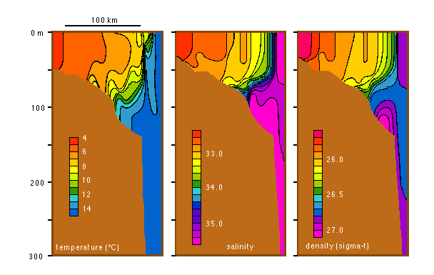 Figure 9.6
A prominent shelf break front is found on the shelf along the Atlantic coast of the USA. Figure 9.6 shows the winter situation south of Rhode Island. Stratification on the shelf is minimal during winter, with temperature increasing from 4ºC inshore to about 8ºC near the front and salinity from 32.5 to about 33.5 but both showing little vertical variation. The water on the seaward side of the front has temperatures of 14 - 16ºC and salinities in the range 35.5 - 36.0, giving a temperature change of 5ºC and a salinity change of 2 across the front. The salinity thus dominates the density field, determining the front's character as a retrograde front. The temperature change works against this but is too small to provide complete density compensation. Taking ($\rho_2 - \rho_1$), in eqn. \ref{eq:rossby}, as 0.5 and $D_1$ as 80 m from the observations we find $R_{bc}$ to be of the order of 10 km. This is clearly borne out by the observations, which show the frontal region to be less than 20 km wide.
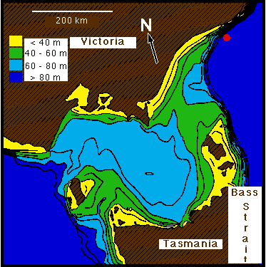 Figure 9.7
 Figurae 9.8
A shelf break front is of course not an impenetrable barrier for shelf and ocean water. If, as in the case of Figure 9.6, the shelf water is less dense than the water of the oceanic surface layer, mixing in the frontal zone will transfer some of it into the ocean. If the shelf water is denser, it will eventually make its way down the continental slope to the depth where the ocean water matches its own density and spread on this density level. An example for this process is provided by Bass Strait, a shallow region between Tasmania and mainland Australia. Bass Strait is bowl-shaped with a maximum depth of 80 m in its centre and sill depths of 55 m on its western and 75 m on its eastern side (Figure 9.7). The seasonal thermocline in the adjacent Tasman Sea is located deeper than the sill depth, and as a result the waters of Bass Strait get about 2ºC colder in winter than the water in the surface layer of the Tasman Sea. This produces a shelf break front along the eastern edge of Bass Strait (Figure 9.8). A small salinity difference between Bass Strait and the Tasman Sea is not large enough to compensate the density effect of the temperature difference, and Bass Strait water is denser than Tasman Sea surface water by about 0.4 in $\sigma_t$.
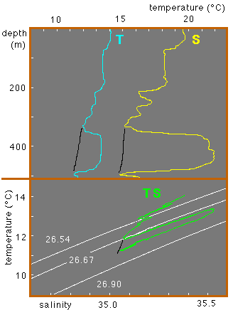 Figure 9.9
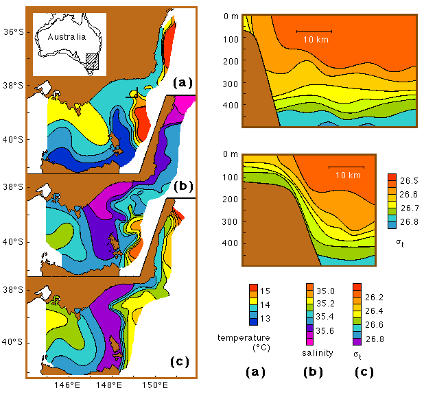
The mean flow through Bass Strait is wind driven and eastward during winter. Bass Strait water therefore moves east towards the front, where it turns northward and continues to spread on the shelf. South of 38º40'S it is contained behind the front; but further north it flows down the continental slope. Most of the downflow, known as the Bass Strait Water Cascade, occurs in a cañon near 38º35'S (Figure 9.8). Further downward movement is observed along the slope to the east and north. At about 400 m the water reaches the level of its own density and begins to flow along the slope as a narrow undercurrent of about 100 - 150 m vertical extent (Figure 9.9).
The last type of fronts found in the coastal ocean, known as shallow sea fronts, is probably the best studied and understood of all fronts. It occurs in shallow regions with moderate to strong tidal currents and is the result of competition between two energy inputs into the ocean. Heat input from solar radiation tends to establish a stratification in the water column. Tidal currents flowing over the sea floor produce turbulent mixing that tends to suppress or destroy stratification. A coastal sea will be stratified where the mixing effect of the tidal current is insufficient to break down the stratification caused by the heating at the surface; it will be totally mixed where the tidal mixing is strong. The boundary between the two regions is marked by a shallow sea front.
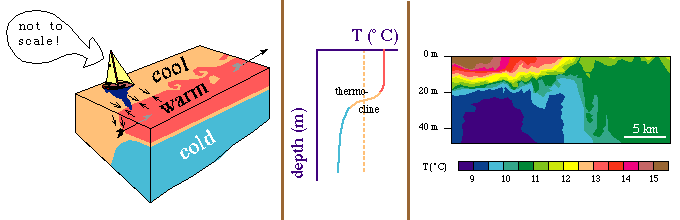 Figure 9.10
It is possible to predict the occurrence and location of shallow sea fronts through an analysis of heat input and tidal current. Heat input is largest in summer and lowest in winter (when in temperate and subpolar climates it turns into heat loss). Tidal currents are weak in the deep ocean but increase in magnitude as the tidal wave enters shallow water. As one approaches the coastal sea from the deep ocean there comes thus a point where the stratification found in the deep sea can no longer be maintained against the increasingly vigorous tidal mixing. The situation is shown schematically in Figure 9.10. The front is associated with a density gradient and thus supports a geostrophic jet along it, which causes eddies to form and break off. Like all other fronts it is also linked with a convergence of the surface current.
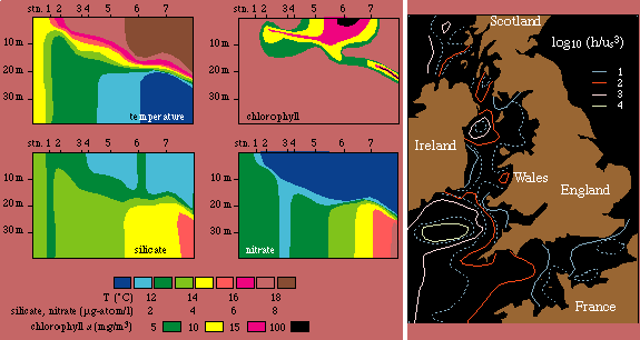 Figure 9.11
Since the temperature in the homogeneous region is the result of mixing the water column from the surface to the bottom, it is colder than the surface temperature in the stratified region but warmer than the temperature in the layer below. It therefore corresponds to the temperature found somewhere in the centre of the thermocline. This unique feature of shallow sea fronts helps in their identification. Figure 9.11 shows the shallow sea front found in the western Irish Sea. The temperature of the mixed region on the right is found in the stratified region on the left at about 18 m depth in the lower thermocline.
Theoretical analysis of the balance between heat input and tidal mixing shows that the location of shallow sea fronts is determined by the ratio $h / u^3$, where h is water depth and u the tidal current amplitude (the maximum tidal current during one tidal period). Shallow sea fronts are therefore also known as $h / u^3$ fronts. Comparison with observations shows that the critical value for the transition from stratified to mixed (ie the location of the front) is somewhere near $\log_{10} (h /u^3) = 2.5$ or so. It is thus possible to predict the existence of shallow sea fronts from a knowledge of water depth and tidal current.
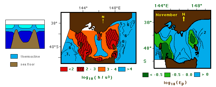 Figure 9.12
Figure 9.12 shows an application to Bass Strait which for a few months during summer becomes stratified. The shelf break front described earlier than makes room for shallow sea fronts on either side of the eastern and western sill. Comparison between $log_{10} (h /u^3)$ calculated from a numerical model of the tides in Bass Strait with the observed stratification shows that Bass Strait is stratified where $log_{10} (h /u^3) > 3$ and mixed where $log_{10} (h /u^3) < 3$. The degree of stratification is expressed in Figure 9.12 through the potential energy $E_p$ stored in the stratification and defined as
\begin{equation} E_p = \int_{-h}^0 (\rho - \rho_{av}) \;g \;z \; dz\label{eq:ep} \end{equation}
where $\rho_{av}$ is the depth-averaged density so that $(\rho - \rho_{av})$ measures the departure from the mean, ie the degree of stratification. This quantity was used because the observations provided only density information; current measurements were not available.
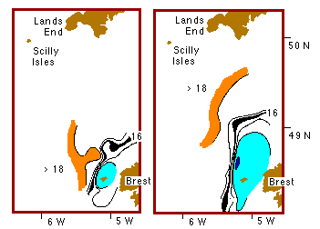 Figure 9.13
The dependence of the frontal location on the magnitude of the tidal current can lead to regular movement of the front. If the tides have a pronounced fortnightly inequality (there is a marked difference between spring tides and neap tides), the frontal location moves offshore during spring tide and retreats into shallower water during neap tide. Figure 9.13 shows an example. Shallow sea fronts have been shown to be regions of strongly enhanced primary production.
Estuaries are a very special part of the coastal ocean, which will be treated in much more depth in the second part of these lecture notes. But a brief discussion of fronts in estuaries is appropriate in the present context.
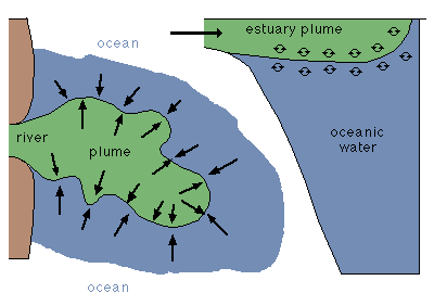 Figure 9.14
Plume fronts form where relatively fresh water reaches the mouth region of an estuary and discharges into the oceanic environment. This can occur in the lower reaches of the estuary or in the form of a fan that protrudes from the estuary into the coastal ocean. Figure 9.14 is a sketch of a plume front extending beyond the estuary mouth. The front around the plume is strongly convergent and turbulent; it is the place where the fresh water from the river is absorbed into the oceanic environment. Plume fronts are often indicated by an accumulation of drifting material such as leaves or foam. The combination of increased turbulence and wind waves or swell coming in from the open sea can make them quite uncomfortable for smaller boats.
While the plume front develops at the mouth of an estuary, the so-called estuarine fronts are not restricted to that area. Where they exist they run parallel to the banks of the estuary at some distance. Dynamically they are a miniature version of the shallow sea front in the sense that tidal mixing competes against buoyancy generated stability of the water column, the difference being that in an estuary the stability is maintained by the salinity rather than the temperature.
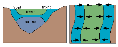 Figure 9.15
Figure 9.15 shows a sketch of an estuarine front. Inflow of river water at the head of the estuary maintains a well developed salinity stratification. In many estuaries this produces a relatively fresh upper layer above a lower layer of near-oceanic salinity. The two layers are separated by a strong halocline. In the deep centre of the estuary the tidal current is not strong enough to overcome the stratification, but in the shallow areas the turbulence produced by the tidal current results in complete vertical mixing. The estuarine front is then formed at the location where the upper halocline breaks the surface.
The major factors responsible for the establishment of the estuarine front are thus water depth and tidal mixing. As a result the estuarine front follows the topography and runs more or less parallel to the shore. It is best developed during periods of strong tidal current and may disappear when the current goes through its slack period.