

![]()
![]()
The properties of the waters in the coastal ocean are constantly changing. Seasonal influences are magnified by the proximity of land, which brings with it an increased annual range in atmospheric temperatures and a concentration of freshwater supply through river runoff. This makes the characterization of water masses more difficult than in the deep ocean, where most of the water is not in contact with the atmosphere.
In the absence of air/sea interaction processes, the physical properties of water parcels can only be changed when they mix with water parcels of different origin and therefore different properties. Without mixing, water parcels retain their temperature and salinity unchanged. Temperature and salinity are therefore know as conservative properties, in contrast to non-conservative properties such as oxygen or nutrients which participate in biochemical processes and therefore show changing concentration levels even in the absence of mixing. Temperature and salinity are therefore the most suitable hydrographic properties to define water masses and study their distribution.
In deep sea oceanography a water mass is usually defined as a body of water with a common formation history. This is based on the observation that water renewal in the deep ocean is the result of water mass formation in contact with the atmosphere, spreading from the formation region without atmospheric contact, and decay through mixing with other water masses. During the spreading and mixing phase a water mass can be followed, and its mixing with other water masses quantified, by analyzing the distribution of temperature and salinity. The idea of a water mass as a body of water implies that it occupies a certain volume in the ocean. This should not be understood to construe sole occupation of a particular ocean region. Sole occupation is the situation in water mass formation regions, where only the locally formed water mass is present. Outside their formation regions water masses mix, and the resulting mixtures share parts of the ocean. Only in theory is it possible to separate the water masses contained in the mixture into sub-volumes, so that each water mass has sole occupation of its particular sub-volume. But the theoretical argument shows that water masses are physical entities which occupy definable volumes.
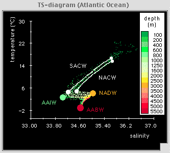 Figure 10.1
The basic tool for water mass classification and analysis is the temperature-salinity (TS-) diagram in which the two conservative properties are plotted against each other. A homogeneous water mass, ie a water mass of uniform temperature and salinity, shows up in a TS-diagram as a single point. North Atlantic Deep Water and Antarctic Intermediate Water (Figure 10.1) are two examples of such water masses. Other water masses display some variation of their properties with depth and are represented in TS-diagrams by curves. The best known examples of this kind are the water masses of the permanent thermocline known as Central Water (Figure 10.1).
The temperature-salinity combinations identified by the water mass points or curves are known as source water types. In the theory of water masses a water type is a point in the TS-diagram; water with the corresponding temperature and salinity may or may not exist. Source water types are TS-points representing water masses as they exist in their formation region. Because they are associated with real water masses it may be more difficult to see why they, too, do not necessarily represent an existing volume of water. But water mass properties are not constant in time; they reflect variations in the atmospheric conditions at the time of water mass formation. One winter may be colder than the previous winter, or it may bring less rain than in the year before, and as a result the newly formed water that is added to the total volume of the water mass may be slightly colder or saltier. If we define the water mass by taking the average temperature and salinity from the two years, the resulting source water type gives a good description of the water mass; but it does not represent any water as it actually exists. A complete description of a water mass requires specification of its source water type (or source water types) and standard deviations (variances) for emperature and salinity. A homogeneous water mass that can be represented by a single source water type has only a single standard deviation for temperature and another single standard deviation for salinity. A water mass represented by a TS-curve (an infinite series of source water types) has two standard deviation curves which together define an envelope around the definition curve.
It takes many years of observations to establish standard deviations for source water types. Often these observations are not available and it is not possible to define the standard deviation envelope. In practice water masses are often defined without standard deviations solely by their source water types, and the two are considered to be the same thing. In the present context it is important to be aware of the difference: a water mass is a physically existing body of water; a water type is a mathematical construct to describe it.
Why do we go to so much length and distinguish between water masses and water types? Why consider standard deviations if in most cases we do not have the observations to determine them? Because a description of water masses in the coastal ocean is on shaky ground without these concepts. The basis of water mass analysis in the deep ocean is that deviations of water mass properties in the formation regions are small compared to the property differences that are observed between different water masses at some distance from their formation regions. Another way of expressing this is that the standard deviation envelopes associated with each water mass are small compared to the total variation of temperature and salinity in space. This makes it possible to distinguish, in Figure 10.1, between North Atlantic Deep Water and Antarctic Intermediate Water. The whole concept of the TS-diagram would be meaningless if the standard deviation envelope of, say, North Atlantic Deep Water were so large that it would include the source water type of Antarctic Intermediate Water. The smallness of the standard deviation envelopes is a useful property of the deep ocean, which brings water masses from distant regions with very different but stable atmospheric conditions into contact with each other.
The situation in the coastal ocean is quite different. To begin with, many coastal regions are well mixed, so TS-diagrams such as the one in Figure 10.1, which show variations of temperature and salinity with depth, are not often found in the coastal ocean. Even where vertical stratification is present, a large part of the water column is still taken up by the surface mixed layer, which in a TS-diagram is represented by a single water type. More importantly, the properties of the mixed layer undergo large changes from season to season. If the TS-properties of the coastal ocean are averaged over the year, the resulting standard deviation is much larger than any variation that may exist as a result of stratification in the water columnat any particular time. We therefore have a situation where defining water masses by source water types and standard deviations becomes meaningless if the concept is applied to the annual mean.
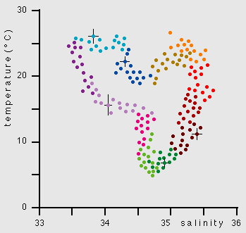 Figure 10.2
Although water properties in the coastal ocean undergo large variations they do not fluctuate in a random fashion but follow a seasonal cycle. It is possible to make use of this and define the water masses of the coastal ocean through the use of the so-called TS-time diagram. Rather than plotting temperature against salinity as both vary with depth (as done in Figure 10.1), we plot the values of both variables in the mixed layer against each other as they vary over the year. Figure 10.2 shows the principle. The sequence of observations taken over a year defines a TS-relationship in time that reflects the weekly and seasonal changes of the two properties. The standard deviations associated with the data points when more than a single measurement was taken on any one day express the daily variability. Taken together the data indicate, for example, that we can expect the temperature of the water mass to be between 24ºC and 26ºC during the warmest month and between 5ºC and 8ºC during the coldest month, while the salinity can be expected to lie between 33.5 and 34.3 and between 34.5 and 35.2 during the two months, respectively.
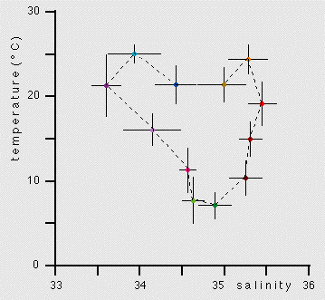 Figura 10.3
Establishing a TS-time diagram for a particular coastal ocean region requires an observational effort over many years and is therefore much more demanding than the effort required to establish a TS-diagram for a deep ocean station. The example of Figure 10.2 assumes that the observations were made over a single year only, so the derived mean TS-time diagram does not necessarily represent climatological mean conditions. (The particular year could have been unusually warm or cold, dry or wet.) Meaningful standard deviations require many observations; but it is rarely feasible to collect data for decades just to establish standard deviations for a water mass definition. In practice the number of data points for the calculation of each standard deviation can be boosted by calculating monthly means and associated standard deviations. This reduces the number of source water types along the TS-time diagram to twelve and increases the number of observations for the calculation of each standard deviation thirty-fold (if the data base consists of daily observations). If the time series of daily measurements is of five year duration we now no longer have five data points for the calculation of daily means but 150 data points for the calculation of monthly means. If this procedure is applied to the TS-diagram of Figure 10.2, the resulting TS-time diagram looks very similar (Figure 10.3); but the standard deviations now represent the variations of temperature and salinity within each month. If the data set consists of observations taken over five years, the standard deviations represent the variations within each month and their variations over the five year observation period. Calculated in this way, the TS-time diagram allows us to define a coastal water mass through 12 monthly water types and associated standard deviations. It enables us to make statements about the temperature and salinity we can expect to find during the warmest and coldest months or any other moment in time, based on climatological expectations. In fact, most of the apparent variability indicated by the data scatter of Figure 10.2 is the result of changes in wind, cloud cover and rainfall on the synoptic scale, ie associated with the weather. These variations are also responsible for most of the standard deviations of Figure 10.3, which mainly reflect changes of properties within particular months.
Even when the TS-time diagram is based on monthly means information is not always available on monthly standard deviations. Nevertheless, any reasonably well defined TS-time diagram is a valuable tool for the coastal oceanographer. By combining its information with knowledge of environmental preferences of various marine life forms the oceanographer, marine park administrator or coastal engineer can give a fairly accurate description of the physical environment, how it varies over the year and how it affects the coastal ecosystem. The technique could be extended to include time diagrams of temperature against chlorophyll content or other biological indicators.
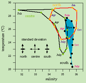 Figure 10.4
Figure 10.4 shows three examples of particularly well defined TS-time diagrams, taken from a review of the physical oceanography of the Great Barrier Reef. They show that three water masses are present in the lagoon. Southern Lagoon Water shows little salinity variation through the year and is very similar to surface water found in the adjacent Coral Sea. The effect of shallow water depth is seen in a somewhat larger annual range in the temperature, from close to 20ºC in winter (July) to nearly 28ºC in summer (February); the corresponding minimum and maximum temperatures in the Coral Sea at 22º S are 22ºC and 26ºC. Central Lagoon Water shows a similar annual temperature variation but about 1.5 - 2ºC higher temperatures, which compares fairly well with the general equatorward increase of surface temperatures in the Coral sea of about 0.5ºC per degree latitude. From May to December the salinity is about 0.6 lower than in the southern region, again similar to conditions in the Coral Sea and corresponding to the equatorward decrease of surface salinity of about 0.1 per degree latitude. During the summer months (January - April) Central Lagoon Water is characterized by very low salinity, a result of freshwater input from rivers. The north of Australia has a monsoonal climate; heavy summer rainfall brings large amounts of freshwater into the lagoon.
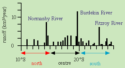 Figure 10.5
The largest of the north Queensland rivers (the Burdekin River) enters the lagoon in its central region, which contains the mouths of more major rivers than the south or the north (Figure 10.5).
The northern region receives about as much freshwater from local rivers as the southern region, but its TS-time diagram is markedly different. Its temperature range is again comparable with that of the adjacent Coral Sea. Salinity, on the other hand, varies much more than in the south. Lowest salinities are again experienced during summer, indicating monsoonal influence. In contrast to the central region where this influence is felt as strongly increased local river runoff over a period of less than two months, in the northern region it is the result of local runoff and freshwater input from the rivers of Papua New Guinea. The Fly River carries about 100 times the amount of water of the Normanby River, the largest of the local rivers in the northern region. Its waters mix with the waters of the Coral Sea before they reach the Great Barrier Reef Lagoon. Its effect on the salinity of Northern Lagoon Water is therefore less pronounced than the effect of the Burdekin River in the central region but it is felt over several months.
The elevated salinities in the northern region during spring and early summer (September - January) contrast with the general equatorward decrease of surface salinity in the Coral Sea. They reflect the high levels of evaporation in the tropics. In coastal regions evaporation is enhanced through the influence of the hot dry land; the air over the coastal ocean is very undersaturated in moisture. This can lead to a significant salinity increase in the coastal ocean during the dry season of the monsoon.
Similar TS-time diagrams can be produced for all other parts of the coastal ocean. They can, in fact, be a useful tool for the analysis of the hydrography of the surface layer in the open ocean, although the idea seems not to have been pursued yet. The observational data base exists and is getting more and more accurate. In the context of coastal oceanography it is worth noting that many shelf seas have been surveyed in great detail over many decades and their data base is suitable for deriving standard deviations on a monthly basis. Regions experiencing summer stratification require two TS-time diagrams, one for the surface mixed layer and one for the layer underneath.