

![]()
![]()
One of the most important processes in the coastal ocean is upwelling, the movement of water from deeper layers of the sea to the surface. It constitutes the other major process for nutrient regeneration in the surface layer; in terms of magnitude and importance it has to be ranked before the process of nutrient regeneration through tidal mixing.
Upwelling in the coastal ocean can be due to a number of factors. In most situations the upwelling is wind driven and its effect on currents, stratification and nutrient supply determined by topographic detail such as water depth and the shape of the coastline. In other situations it is the response to variations in the currents found just outside the coastal ocean and therefore independent of coastal wind conditions. We refer to this type of upwelling is dynamic uplift. The appropriateness of this term will become clear from the discussion of its dynamics below.
A discussion of wind-driven upwelling begins with the situation in the deep ocean. Coastal upwelling systems in the deep ocean have been studied in the Atlantic and Pacific Oceans in great detail. They form an integral part of deep ocean dynamics, and detailed descriptions can be found in textbooks on open ocean dynamics. Tomczak and Godfrey, 1994 give a review of all deep ocean upwelling regions. In the present context a brief summary of its main features must suffice to set the scene for a more detailed discussion of the modifications found in the coastal ocean.
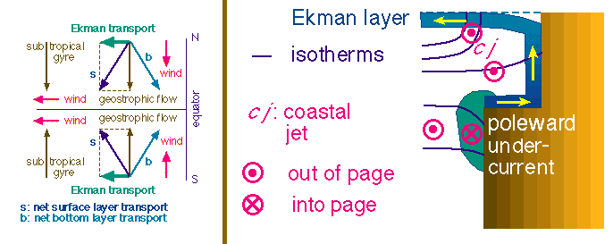 Figure 6.1
In the deep ocean coastal upwelling occurs where the wind blows parallel to the coast with the coastline on its left (right) in the northern (southern) hemisphere (Figure 6.1). This produces a surface Ekman layer transport directed 90º to the right (left) of the wind direction; in both hemispheres, this results in offshore surface water movement. The associated lowering of the sea surface near the coast produces a pressure gradient which is directed normal to the shore and drives a geostrophic current along the coast, in the same direction as the wind. The effective water movement is the result of both the wind-driven Ekman flow and the geostrophic flow. It is therefore directed at an angle away from the coast near the surface, parallel to the coast at mid-depth (below the Ekman layer but above the bottom boundary layer) and at an angle towards the coast in the frictional boundary layer at the bottom.
Upwelling regions controlled by these dynamics are found in the subtropics, where the Trade Winds blow towards the equator along the eastern coastlines of the oceans. At these latitudes the oceanic circulation further offshore is dominated by the subtropical gyres, large ocean circulation systems that reach from coast to coast across the ocean basins. In their eastern parts these gyres display poleward flow, so water movement in the gyre is in the same direction as in the adjacent upwelling region. The two flows blend into each other, and a distinction between them can only be made on the basis of the hydrographic structure associated with the upwelling, shown in the second diagram of Figure 6.1. The upper thermocline, which in the open ocean is found at 200 - 400 m depth, rises towards the surface as the coast is approached. This is the result of upward water movement in a frictional boundary layer at the coast. The boundary layer is some 20 - 100 km wide and owes its existence to the need to replace the water that is transported seawards in the surface Ekman layer. If the upwelling is strong or continues for a sufficient length of time, the thermocline eventually breaks the surface and is then seen as a front along the coast which moves back and forth depending upon the strength of the upwelling. Geostrophy establishes a strong current at the front. This coastal jet is observed as an intensification of the equatorward flow and can be regarded the boundary between the coastal upwelling circulation and the subtropical gyre.
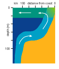 Figure 6.2
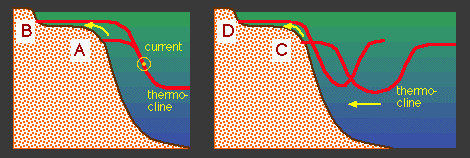 Figure 6.3
The water which rises near the coast has to be supplied from the offshore region. On the shelf this occurs in the bottom boundary layer. Further offshore the water comes from mid-depth in the form of slow geostrophic onshore drift over the upper few hundred metres. This drift is maintained by a pressure gradient that is directed from the equator to the pole and the result of the large scale oceanic circulation. The balance of forces in the onshore drift, a poleward pressure gradient force opposed by an equatorward Coriolis force, cannot operate in the immediate vicinity of the continental slope where onshore movement and therefore the associated Coriolis force go to zero. Close to the continental slope the water therefore runs down the pressure gradient in a poleward undercurrent, and the steady state is established between the pressure gradient force and friction along the slope. In the coastal ocean the upwelling process is modified in a number of ways. The deep ocean situation prevails where the shelf is deep enough to accommodate a surface Ekman layer, a bottom boundary layer and a geostrophic layer inbetween. Observations show that in upwelling regions the Ekman layer thickness is often smaller than in the open ocean, presumably because upwelling brings the thermocline closer to the surface inhibiting wind mixing beyond a depth of 20 - 30 m (see Chapter 3). A depth of 200 m is therefore sufficient to allow the deep ocean situation to develop. Figure. 3.3 gave an example from the Canary Current upwelling in water depth of only 74 m. Figure 6.2 shows the circulation normal to the coast derived from observations along the southern coast of Australia in similar water depth. Both observations suggest that a depth of 60 m or more is sufficient to accommodate deep ocean upwelling dynamics. In other words, in water depth exceeding 60 m strongest upwelling can be expected to occur when the wind blows parallel to the coast with the coastline to its left (right) in the northern (southern) hemisphere.
The other assumption of the schematic of Figure 6.1 is that the coastline is vertical and the full water depth of the coastal ocean is attained without transition. This condition is rarely met in the real world. In a realistic situation there has to be a zone along the coast where the surface and bottom boundary layers merge. The question arises how this affects the conditions for wind driven upwelling.
The key factor for wind driven upwelling is the direction of the Ekman layer transport relative to the coast. Optimum upwelling conditions are obtained when the Ekman transport divergence is maximized, which occurs when the Ekman transport is directed offshore and normal to the coastline. Going back to the discussion of Chapter 3 and recalling that the Ekman layer transport gets more and more aligned with the direction of the wind as the water depth decreases, we find that the wind direction most favourable for upwelling is parallel to the coast in deep water but becomes more and more perpendicular to the coast as the water gets shallower. This is in keeping with the experience of beach goers that offshore winds tend to make waters cold for swimming; they drive the warm surface water offshore, causing the colder water underneath to upwell in the inshore zone.
Since the water depth decreases gradually from the mean depth of the shelf towards the land there has to be a transition from deep ocean upwelling to shallow water upwelling as the land is approached. Before looking at this transition in detail we consider briefly the other upwelling process that can occur in the coastal ocean.
From the point of view of marine life, the most important effect of upwelling is the replenishment of the surface waters with nutrients. If the deep ocean circulation contains a fast flowing current next to the continental slope, variations in the strength of this current can produce an uplifting of colder nutrient-rich waters from the deep ocean onto the shelf. This can occur in two ways, through geostrophic adjustment of the mean circulation and through tidal pumping. Both processes are independent of local wind conditions and can therefore occur in regions where wind-driven upwelling cannot develop.
Consider the situation in a western boundary current (Figure 6.3). The oceanic temperature field reacts to the presence of the current by adjusting to geostrophic equilibrium, which leads to a steep rise of the thermocline from the ocean towards the coast. The depth difference of the thermocline across the current is proportional to the current's speed. Since the current forms the western part of a large oceanic gyre its strength is determined by Sverdrup circulation of the open ocean and independent of local wind conditions. A change of current speed produced by changes in the Sverdrup circulation will result in a change of the thermocline depth difference across the current.
The depth of the permanent thermocline in the open ocean is determined through the Sverdrup relationship by the curld of the wind stress (see Chapter 3) which is more or less constant. Variations in thermocline depth difference therefore manifest themselves as changes in thermocline depth on the inshore side of the current, and an increase in current speed leads to a change of thermocline position in Figure 6.3 from A to B. It is seen that the upper permanent thermocline can on occasions "invade" the coastal ocean, supplying it with cold nutrient-rich water from the open ocean.
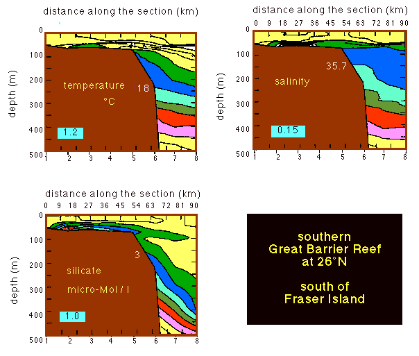 Figure 6.4
The process, which might be appropriately called dynamic uplift of the thermocline, has been documented for the Agulhas Current, which produces frequent upwelling of the Agulhas Bank off southern Africa (Walker, 1986). It is observed regularly on the east Australian shelf near Sydney, produced by the East Australian Current. Fig. 6.4 shows an example from a location on the same shelf but 1000 km further north. The process applies to all western boundary currents, and other examples can be found in all oceans on both hemispheres.
Dynamic uplift often occurs in brief events of only a few days' duration. The reason is that the variations in thermocline depth experienced at the continental slope and further inshore are mostly not the result of variations in the mean speed of the current but of instabilities associated with it. The instabilities occur in two forms, variations in the current's position and eddy formation. On average, western boundary currents are located just offshore from the continental slope, and their influence does not reach far into the coastal ocean, which establishes its own circulation dominated by local wind and thermohaline forcing. Every now and then the boundary current impinges on the outer shelf, producing an upwelling event through dynamic uplift.
The second form of instability is eddy formation. Western boundary currents spawn several eddies per year, and these eddies maintain their identity for two years or longer. They are broken off pieces of the main current and therefore show the same current width and speed as the boundary current. As they slowly move away from their formation region they can impinge on the continental slope. Warm core eddies are characterized by a deep thermocline in the centre and shallow thermocline depth around the eddy fringe (for a detailed explanation of eddy formation and structure see Tomczak and Godfrey, 1994), so the thermocline will be lifted up when a warm core eddy approaches the shelf (Figure 6.3). The effect is the same as when the main current impinges on the shelf. The basis for dynamic uplift is the existence of a strong current along the continental slope. Western boundary currents are obvious candidates, but other regions may also have favourable conditions. Many areas of the coastal ocean are not influenced by strong currents of the mean oceanic circulation but experience strong tidal currents. This can produce upwelling through tidal pumping.
The basis for tidal pumping is amplification of the tidal current and associated turbulence through topographic effects. Tidal currents are periodic and move water onto and off the shelf in a regular way. Net nutrient transport from the ocean interior onto the shelf can only occur if the water lifted onto the shelf during flood tide is mixed with the shelf water, enabling it to transfer part of its nutrient load to the waters on the shelf before being removed again during ebb tide. Particularly favourable conditions for such mixing are found where a chain of islands separates the shelf from the open sea, leaving only restricted access to the tidal wave. The tidal currents through the channels between the islands are then extremely strong, and the associated island wakes (see Chapter 7) result in intense mixing on the shelf. Each flood tide brings another load of nutrients onto the shelf, and the resulting nutrient enrichment can be substantial. The process has been documented for locations in the Great Barrier Reef, where marine life on the outer reefs benefits greatly from tidal pumping (Thompson, 1981). Similar geographical settings, amplification of tidal currents in channels between islands on the outer shelf, exist in other locations. It is likely that tidal pumping is an important contributor to the nutrient supply of the coastal ocean in all these situations.
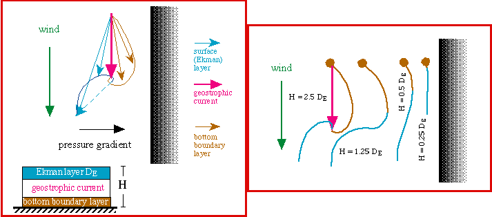 Figure 6.5
The different types of upwelling do not usually occur in isolation but can coexist in any part of the coastal ocean, depending on its topography, the prevailing wind directions and the conditions in the adjacent deep ocean. Figure 6.5 is a summary of the current structure in coastal upwelling regions of different water depth. It shows that the direction most favourable for upwelling changes as the water depth decreases. The result is a zonation of the shelf into regions of different upwelling dynamics (Figure 6.6). Upwelling in the inner zone occurs when the wind is directed offshore. Upwelling on the middle shelf develops under alongshore winds with the coast on the left (right) of the wind in the northern (southern) hemisphere. Additional upwelling events can be present in the outer zone, produced either by variations in the adjacent oceanic current or by tidal pumping.
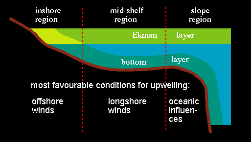 Figure 6.6
A simple way of identifying the upwelling zonation of a particular shelf region is by obtaining observations of sea surface temperature at a number of locations across the shelf and correlating them with the local wind. The sea surface temperature is used as a proxy for upwelling; low temperature indicating strong upwelling conditions. It is then found that in the inner zone the highest correlation is between sea surface temperature and the wind component normal to the coast; sea surface temperature is lowest when the wind blows from land to sea. In the middle zone the highest correlation is between sea surface temperature and the alongshore wind component. The outer zone shows a similar correlation; but this can be masked by the presence of dynamic uplift or tidal pumping. Observations from the coastal ocean off Sydney, Australia, show that the strongest upwelling influence in the outer zone comes from the East Australian Current. Water temperatures in the outer zone are low when the current passes close to the continental slope and high when it passes further out to sea. This requires an additional observational parameter as a proxy for the East Australian Current and a test for the presence of dynamic uplift. The temperature at 250 m depth some distance from the shelf is often used to identify the current axis but is not easy to obtain on a regular basis (for details see Tomczak and Godfrey, 1994). Surface current speed over the continental slope can be otained from ships entering Sydney harbour and can be used as an indicator.
The observations off Sydney indicate that the transition from the inner to the middle zone occurs somewhere in the vicinity of the 30 - 40 m water contour. This supports our earlier statement that most shelf regions are deep enough to accommodate deep ocean upwelling dynamics. The inner zone is usually only some 20 - 30 km wide. From the point of view of coastal engineering it is a most important part of the coastal ocean since it is ususally the zone that contains all sewer outlets and other sources of effluents. An active upwelling circulation returns all material introduced near the bottom of the coastal ocean back to the coast. When and how often this happens is determined by the shallow upwelling dynamics of the inner zone, unless of course the point of introduction is moved further seaward into the middle zone. The city of Sydney decided to replace all its coastal sewage outlets by pipes which release the sewage near the ocean floor several kilometers from the coast. At this distance the release points are still in the inner zone. The public debate over this costly decision fills several volumes, which unfortunately cannot be included here.
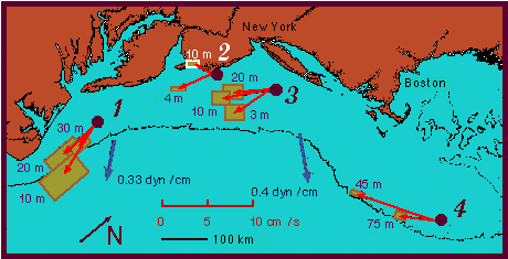 Figure 6.7
The shelf region of the Middle Atlantic Bight, along the oast of eastern USA between 35ºN and 45ºN, provides a good example of a shelf with a particularly wide inner zone. Figure 6.7 shows long term mean currents at four locations and long term mean wind stresses at two locations. The current data were collected over various periods between May 1972 and December 1978; the shortest record was 469 days. The observations show that the zonation into shallow and deep water upwelling can be seen even in long term mean observations. Stations 1, 2 and 3 were respectively in 38, 12 and 47 m of water and display shallow water upwelling dynamics: The mean prevailing wind is directed offshore at stations 2 and 3, producing offshore surface currents and onshore bottom flow. This structure is superimposed on the general shelf circulation. At the shallow depth in the inner zone there is no room for a frictionless interior with geostrophic flow; so the mean flow cannot be the result of geostrophic adjustment to the wind forcing (which would result in flow to in a direction opposite to the one observed). On the Middle Atlantic shelf it is produced by sea-level setup and directed southward, driven by a rise in sea level along the coastline from south to north. It is seen that the vertical veering of the currents occurs with a sense of rotation opposite to that found in deep water upwelling (Figure 6.1). The sense of rotation depends of course on the direction of the alongshore pressure gradient and can therefore vary from situation to situation.
Mean wind conditions at station 1 are not as favourable for upwelling as at stations 2 or 3. In deep water the wind would produce downwelling. In shallow water the small offshore wind component can still drive an upwelling circulation; the current observations show that this seems to be the case, although the veering near the bottom is not clearly observed. In contrast, bottom currents at station 4, which is in 85 m of water, clearly show an offshore veering relative to the flow in mid-depth, indicating a circulation of the deep water type. With the given mean wind direction the deep outer shelf is dominated by downwelling, which means that the deep water upwelling circulation of Figure 6.1 is reversed; onshore flow is found in the surface layer, offshore flow near the bottom.
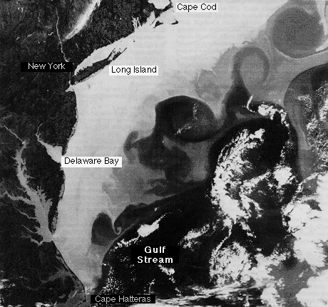 Figure 6.8
The possibility of dynamic uplift along the outer shelf is not evident from the long-term current meter records. It is probably too intermittent and patchy as to make a mark in a multi-annual mean. Its presence can be judged from satellite images of the sea surface temperature (Figure 6.8) which show the Gulf Stream passing offshore as a band of warm water and a sequence of warm core eddies impinging on the shelf. The shelf region itself is covered with cold water. Some of it is pulled offshore in wrapped around warm eddies; at other locations warm water can be seen extending towards the shelf, and two warm eddies are located in close vicinity of the shelf break.
Finally, it should be noted that the simple two-dimensional zonation picture developed here assumes a straight coastline. Real coasts can be ragged and irregular in shape, with promontories, headlands and bays. Since such details of the coastal topography all occur in the inner zone they modify the occurrence of shallow water upwelling along the coast. Centres of upwelling are then found wherever the wind blows in an offshore direction normal to the local orientation of the coastline. This can occur regularly behind headlands along a coast that is devoid of upwelling otherwise. This type of localized upwelling is sometimes called topographically controlled upwelling. It is most effective if the size of the topographic features that produce it is comparable with the width of the inner zone.