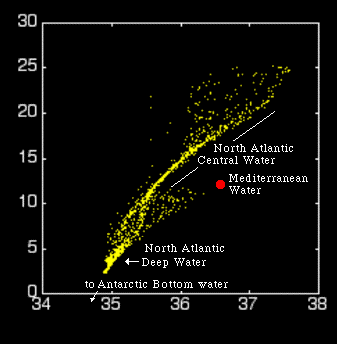


The temperature-salinity (TS) diagram on the left shows the data from all stations. The red point indicates undiluted Mediterranean Water (MW) as it comes through the Strait of Gibraltar. As you can see, undiluted Mediterranean Water is not found at any of the stations supplied for this exercise, but the presence of Mediterranean Water with various percentage contributions is clearly indicated by the data points scattered in a triangular region between the North"antic Deep Water (NADW), the lower temperature point of North "antic Central Water, and the Mediterranean Water itself.
In this exercise the dilution of Mediterranean Water as it moves through the "antic Ocean is measured by distance of the observed TS-combination of a water sample from the line that connects the TS-points (11.5 ºC, 35.7) and (4.0 ºC, 35.0), measured along the line that goes through the observed TS-combination and the TS-point for Mediterranean Water. This technique is used in the mixing calculator of the next page.