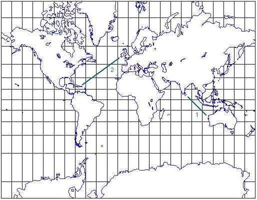
The Mercator projection is a basic scientific tool for navigation at sea and in aircraft. Its mathematically derived design shows the surface of the world such that the correct compass course between any two points can be read from the map as the angle of the straight line between the two points on the map (a map property known as "fidelity of angle"):
The compass course from Northwest Cape in Australia to Sri Lanka (line 1) is 315° (toward NW), the compass course from Ireland to Jamaica (line 2) is 225° (toward SW).
The Mercator projection does not conserve area (as indicated by the varying distance between the horizontal lines that depict lines of constant latitude); in fact, area goes to infinity as the poles are approached. The North and South Pole can therefore not be shown in Mercator projection. Regions and continents are shown in extremely misleading sizes, as can be appreciated by comparing Greenland with Arabia or North America with Africa on the map and on the globe:


The Mercator projection should therefore not be used for geographical maps; it is strictly a scientific tool for navigation. Geographical maps require fidelity of area; such maps are also known as equal area projections. Several variations of such projections have been derived over the centuries; two examples are shown below.
The Mollweide projection, developed by the German mathematician Karl Brandon Mollweide (1774 - 1825).

The Hammer projection, developed by the German cartographer Ernst Hammer in 1892.
