 The Kremer family had moved from Germany to Flanders (in today's Belgium), where Gerard was educated in Christian doctrine, dialectics and Latin. From 1530 he studied philosophy at the university of Louvain and received his master's degree in 1532.
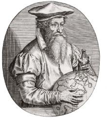
Cartographer, b. 5 March 1512 (Rupelmonde, Flanders), d. 2 December 1594 (Duisburg, Germany).
The Kremer family had moved from Germany to Flanders (in today's Belgium), where Gerard was educated in Christian doctrine, dialectics and Latin. From 1530 he studied philosophy at the university of Louvain and received his master's degree in 1532.
After two years of struggle over the question how to reconcile Aristotle's description of the origin of the Earth with the account of the Bible Gerard dropped philosophy and turned to geography. To provide himself with a solid scientific base he studied mathematics and astronomy. He also adopted the Latinized version Mercator of his name (Kremer is German for shopkeeper, which translates to mercator in Latin).
Mercator joined the workshop of the engraver Gaspar à Myrica, where he learned the secrets of the art and became an excellent engraver himself before he reached 24. Together with Myrica and the mathematician Gemma Frisius he made Louvain into a centre for the production of globes, maps and astronomical instruments. In the following years he established his reputation as the leading geographer of the 16th century with maps of Palestine, the World, Flanders and others.
In 1544 Mercator and 42 others were arrested and charged with heresy on suspicion that his frequent travels for the collection of geographical information were motivated by a leaning towards Protestantism. The university supported him in his defence, and after seven months he was released from jail.
In 1554 Mercator moved to Duisburg, established his own workshop and started as a publisher of maps in his own right. In 1564 the Duke Wilhelm of Cleve appointed him as "cosmographer" to his court in Duisburg. Mercator continued to publish maps, of the Lorraine and of the British Isles among others, and in 1569 he published another map of the World.
The projection used in the 1569 world map, today known as the Mercator projection, was a significant scientific invention. It allows a navigator at sea to read the correct compass course between the port of departure and the intended port of arrival as the angle of the straight line between the two ports on the map. It is still an essential tool for navigation on ship and aircraft today.
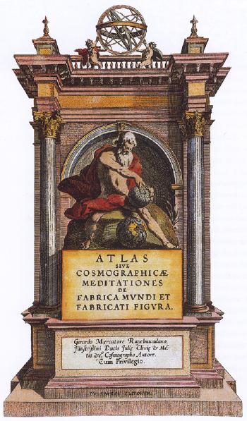
Following his new world map Mercator embarked on a major work, intended for serial publication, that was to describe the history and geography of the world. He gave his project the name Atlas, a term that has since been adopted for an annotated collection of maps. Mercator did not complete his Atlas, but the work was continued after his death by Hondius and others. The sections that appeared covered
Mercator, Gerardus. Encyclopaedia Britannica 15th ed. (1995)
Illustration: public domain (Wikipedia)
Title page of Mercator's maps in three volumes, published posthumously by Kremer's son Rumold in 1595, which for the first time uses the description "Atlas" for a collection of maps:
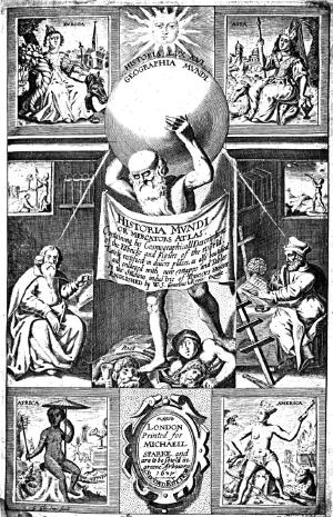
The title page of Mercator's Atlas in an English edition of 1637. The text reads:
HISTORIA MUNDI or MERCATORS ATLAS. Containing his Cosmographicall Descriptions of the Fabricke and Figure of the World. Lately rectified in divers places, as also beautified and enlarged with new Mapps and Tables by the Studious industrie of TODOCVS HONDY. ENGLISHED by W. S. Generosus & Regin: Oxonae.
The four corner vignettes show Europa and Asia at the top and Africa and America at the bottom.
Images: public domain