

![]()
![]()
There is a huge number of estuaries in the world, and most of them are either not explored at all or only cursorily understood. When faced with the task to assess the situation of estuaries along a stretch of coast about which not much is known, a very useful first step is to identify the classes of estuaries that can reasonably be expected to exist along that coast. This allows one to determine a strategy for the necessary observations if and when it is decided that more knowledge has to be acquired. This last chapter of these lecture notes demonstrates how this can be done. Being based on a course given in Australia, it uses that continent as an example; but the principle will become clear and can be applied anywhere.
The basis for any estuarine classification is the ratio R/Vof river volume per tidal cycle R over tidal volume V (the volume of water imported into the estuary and removed by the tide during one tidal cycle). Where this ration is not know for a given estuary it can with reasonable accuracy be estimated from tidal and rainfall data, which are usually available. Tide tables can give a very good idea of the tidal range that can be expected along a coast, and rainfall data from coastal and inland towns are usually collected by the meteorological services and can give an idea of the river discharges, especially when they are used in combination with information on catchment areas.
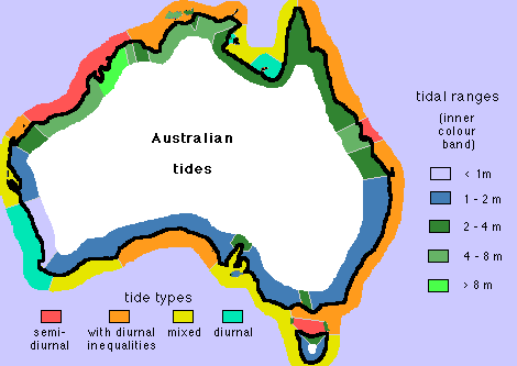 Figure 18.1
When this principle is applied to Australia, it leads to several natural subdivisions of the coastline. Figure 18.1 gives the tidal range for all major Australian coastal locations. It shows that the tides are extremley large in the north (on the North West Shelf and across the Timor Sea and the Gulf of Carpentaria). Going clockwise around the continent, the tides are of moderate range along the east coast and in the south east (Bass Strait and Tasmania) and decrease further to small tidal range in the south and very small to insignificant in the south west and west, before they increase rapidly as the north west is reached again.
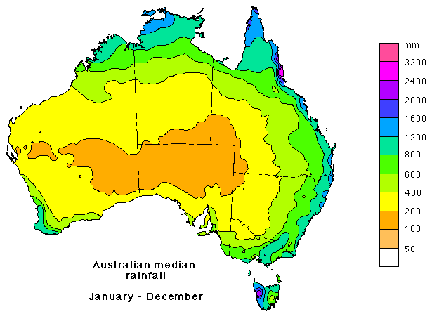 Figure 18.2
The second piece of information required is rainfall. Annual mean rainfall can be used as a first approximation, but it can be misleading where the rainfall is highly seasonal. The annual average rainfall, shown in Figure 18.2, indicates a subdivision of the Australian coast into a high to extreme rainfall region in the north, moderate rainfall in the east, south east and south west, and very low rainfall in the south and north west. If this is further detailed into summer rainfall and winter rainfall it is seen that the high rainfall in the north falls exclusively during summer, when the northwest monsoon brings moist air to the coast and with it daily thunderstorms; rainfall in the south west is predominantly winter rainfall; and rainfall along the east coast and in the south east is rather evenly distributed throughout the year.
Additional information that has to be taken into account are
The information can be combined into a classification of Australian estuaries, shown in the following table.
| region | tidal range | rainfall | estuary type | example | ||
|---|---|---|---|---|---|---|
| summer | winter | summer | winter | |||
| east and south east |
moderate | moderate | slightly stratified if the catchment is large enough to suppress rainfall variability; intermittent otherwise | Hawkesbury River, Derwent River (slightly stratified), Port Hacking (intermittent) | ||
| south | small | nearly none; large evaporation | moderate; large evaporation | inverse | Spencer Gulf, St. Vincent Gulf | |
| south west | small | a little | moderate | slightly stratified | highly stratified | Swan River |
| north and north east |
large to extreme | very large | nearly none; large evaporation | slightly stratified | salt plug | South Alligator River, Wenlock River |
A similar table can be developed for any part of the world ocean's coastline, provided the rainfall, evaporation and tidal data are available and the catchment areas of all rivers are known.