![]()
![]()
Probably the most basic task in describing an estuary is to establish an estimate for its mean circulation. Estuary classification is a first step in that direction, but it is qualitative, not quantitative. This chapter discusses methods to derive volume transports from observations of the salinity distribution. Such methods are based on the principle of salt conservation and therefore known as salt balance techniques.
It might appear that the most direct way of finding volume transports is to measure the current at various depths. But the current in an estuary is usually dominated by the tide. To extract the mean circulation from current measurements therefore requires current measurements over at least one tidal cycle, which is a time consuming and costly exercise. The salinity field is moved back and forth with the tide, but the vertical salinity profile (the variation of salinity with depth) is not affected by the tidal movement and can be obtained from a single measurement. It is for this reason why oceanographers spent considerable effort on developing methods to deduce the mean circulation in an estuary from salinity observations.
The basis for salt balance techniques is the diffusion equation for salt. For a two-dimensional estuary it can be written as
\begin{equation}\dfrac{\partial (u S)}{\partial x} + \dfrac{\partial (w S)}{\partial z} - \dfrac{\partial}{\partial x} ( K_h \dfrac{\partial S}{\partial x}) - \dfrac{\partial}{\partial z} ( K_v \dfrac{\partial S}{\partial z}) = 0 \label{eq:dif} \end{equation}
$u$ and $w$ are the horizontal and vertical component of velocity, $S$ is salinity, $K_h$ and $K_v$ are the horizontal and vertical turbulent diffusion (Austausch) coefficients for salt, $x$ is the horizontal coordinate measured positive from the inner end of the estuary towards the sea and $z$ is the vertical coordinate measured positive downward. The first term in the equation expresses transport of salt by horizontal current (horizontal advection). The second term expresses transport of salt by vertical water movement (vertical advection). The third term represents the net transport of salt from horizontal turbulent mixing, and the last term gives the contribution to the salt transport from vertical turbulent mixing. Note that all turbulent mixing is the result of tidal action; the importance of turbulent mixing in the balance of salt transport processes therefore depends on the strength of the tide.
The equation can be simplified for the different classes of positive estuaries. In the salt wedge and highly stratified estuary all salt transport is achieved by advection only, and the diffusion equation for salt represents a balance between horizontal and vertical advection:
\begin{equation}\dfrac{\partial (u S)}{\partial x} + \dfrac{\partial (w S)}{\partial z} = 0 \label{eq:cont} \end{equation}
The vertical velocity $w$ here represents the effect of entrainment from the lower layer into the upper layer.
In the slightly stratified estuary movement of salt between the upper and lower layer is achieved by turbulent mixing. Horizontal mixing is still small and unimportant, and the diffusion equation gives a balance between three processes:
\begin{equation}\dfrac{\partial (u S)}{\partial x} + \dfrac{\partial (w S)}{\partial z} - \dfrac{\partial}{\partial z} ( K_v \dfrac{\partial S}{\partial z}) = 0 \label{eq:difs} \end{equation}
The vertically mixed estuary is characterised by vertically uniform property distributions, which means that all terms in the diffusion equation which express vertical changes vanish. This leaves again a balance between only two processes, horizontal advection and horizontal tidal turbulent mixing, which becomes essential to the balance:
\begin{equation}\dfrac{\partial (u S)}{\partial x} - \dfrac{\partial}{\partial x} ( K_h \dfrac{\partial S}{\partial x}) = 0 \label{eq:x} \end{equation}
A variation on the last situation occurs in vertically mixed wide estuaries which display a significant lateral salinity variation (variation of salinity across the estuary). In such situations mixing in the lateral direction (horizontal mixing across the estuary) and lateral advection (water movement across the estuary) are usually more important than up-estuary diffusion (horizontal mixing along the axis of the estuary). The diffusion equation then represents a balance of three processes, one in the direction $x$ of the estuary axis and two in the direction $y$ across the estuary ($v$ here refers to the velocity component in the $y$ direction):
\begin{equation}\dfrac{\partial (u S)}{\partial x} +\dfrac{\partial (v S)}{\partial y} - \dfrac{\partial}{\partial y} ( K_h \dfrac{\partial S}{\partial y}) = 0 \label{eq:xy} \end{equation}
The salt wedge and highly stratified estuary are particularly accessible to an easy description of their circulation because salt transport in these estuaries is a balance between only two processes, horizontal and vertical advection of salt. This makes it possible to derive some simple calculation schemes for the determination of the mean circulation. They are based on the principles of conservation of volume and conservation of salt and known as Knudsen's hydrographical theorem.
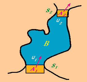 Figure 14.1
To begin with, consider the situation shown in Figure 14.1: Water flows through a channel with an entry area $A_1$ (given by the product of width and depth) and an exit area $A_2$. We define the direction of flow as going from $A_1$ to $A_2$. Expressed in other words, this means that the flow is from $A_1$ to $A_2$ if the flow velocity is positive and from $A_2$ to $A_1$ if it is negative. Let the inflow velocity be $u_1$ and the outflow velocity $u_2$. Let the salinity of the water entering the channel be $S_1$ and the salinity of the water leaving the channel be $S_2$. The volume transport per unit time or volume flux Q is then given by $Q_1 = A_1 u_1$ at the entry section and $Q_2 = A_2 u_2$ at the exit; the amount of salt entering the channel per unit time or salt flux is given by $Q_1 S_1$ and the salt flux at the exit by $Q_2 S_2$. Our aim is to determine the flow through the channel, ie $Q_1$ and $Q_2$, from measurements of the salinities $S_1$ and $S_2$ at the entry and exit.
Assume now that there is a source of freshwater in the channel, for example rainfall. Let the rainfall rate be $r$ and denote the surface area of the channel by $B$. The volume of water added by the rain per unit time is then $R = rB$. If the situation is in a steady state, conservation of volume requires that the amount of water entering the channel per unit time has to be balanced by the amount of water leaving it:
\begin{equation}Q_1 + R = Q_2 \label{eq:bal1} \end{equation}
Conservation of salt requires that the amount of salt entering the channel per unit time has to be balanced by the amount of salt leaving it. Since rain does not add salt to the system, the salt balance contains only two terms, the incoming salt flux and the outgoing salt flux:
\begin{equation}Q_1 S_1 = Q_2 S_2 \label{eq:bal2} \end{equation}
Note that meteorological services usually give rainfall rates in mm/day. To evaluate equation (14.6) we have to be consistent in the use of units and use the international scientific system of units throughout, which gives length in m and expresses time in s. We therefore measure $A_1, A_2$ and $B$ in $m^2$, $u_1$ and $u_2$ in m s-1 and convert $r$ from whatever units the meteorological service uses to m s-1.
The volume balance \eqref{eq:bal1} and the salt balance \eqref{eq:bal2} give us two equations for the two unknowns Q_1 and Q_2. We can solve for Q_1 and Q_2 and find
\begin{equation}Q_1 = \dfrac{R}{\dfrac{S_1}{S_2} - 1}, \quad Q_2 = \dfrac{R}{ 1 - \dfrac{S_2}{S_1}} \label{eq:sol} \end{equation}
A quick inspection of this result shows that if $R > 0$ (rain is added to the system) the water moves from the region of high salinity to the region of low salinity as expected, getting diluted on the way: If $S_1 > S_2$ it flows from $A_1$ to $A_2$ ($Q_1$ and $Q_2$ are both positive), if $S_2 > S_1$ it flows from $A_2$ to $A_1$ ($Q_1$ and $Q_2$ are both negative). If, on the other hand, evaporation over the channel exceeds precipitation, we have $R > 0$ and the flow is from the region of low salinity to the region of high salinity, with concentration of salt on the way.
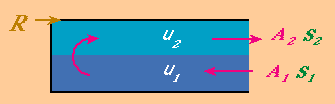 Figure 14.2
We can easily convert the example of a channel with an entry and exit area into a salt balance of an estuary. All we have to do is fold the channel over in such a way that the exit area is located above the entry area (Figure 14.2). This gives us a two layer representation of a highly stratified estuary. Rather than assuming that the freshwater input is derived from rain we now concentrate the freshwater input in one place at the inner end of the estuary and interpret $R$ as the flow rate (volume per unit time) of the incoming river. Equations \eqref{eq:bal1} and \eqref{eq:bal2} can then be applied directly to the situation in the estuary if we interpret positive values of $Q_1$ as inflow at the estuary mouth through the lower layer and positive values for $Q_2$ as outflow at the estuary mouth through the upper layer.
From Figure 14.2 it is evident that all water which enters the lower layer of the estuary through $A_2$ has to leave it through the upper layer. In a highly stratified estuary this is achieved by entrainment. We can estimate the entrainment velocity $w$ (the upward velocity at the interface between the two layers) if we know the area $B_e$ of the estuary. We then have
\begin{equation}w B_e = Q_2 = \dfrac{S_1}{S_2 - S_1} R \label{eq:ent} \end{equation}
Fjords are particularly good examples of highly stratified estuaries. In the Hardangerfjord of Norway the ratio $S_1/(S_2 - S_1)$ varies between 2 and 6 during the summer months, which means that the amount of water leaving the estuary at the mouth is between 2 and 6 times the amount of freshwater which enters it from the river. The entrainment velocity $w$ comes out as about $5 \times 10^{-6} m\;s^{-1}$, which is a vertical ascent of 0.45 m per day.
Equation \eqref{eq:sol} allows us to determine the increase of the volume flux from the river to the sea from a single measurement of salinity as a function of depth in the vicinity of the estuary mouth. All we have to do is make an educated decision where the interface for the two layers is likely to be and determine the mean salinity $S_1$ and $S_2$ of the upper and lower layer. To get a reliable result the measurement should be done at a location where the salinity still shows a clear variation with depth since equation \eqref{eq:sol} becomes meaningless when we reach the sea where $S_1 = S_2$. In the absence of direct current measurements the location of the interface can be estimated from the salinity profile as the depth where the vertical salinity gradient is largest.
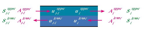 Figura 14.3
We can generalise this result by looking at the volume and salt balance for individual sections of the estuary. Assume that observations of salinity were taken along an estuary at a number of stations and consider the situation between two neighbouring stations $i$ and $i-1$ (Figure 14.3):
We have throughflow occurring in the upper layer and throughflow in the opposite direction in the lower layer. The balance equations thus involve four areas, $A_i^{upper}$ and $A_i^{lower}$ and $A_{i-1}^{upper}$ and $A_{i-1}^{lower}$ with four velocities $u_i^{upper}$, $u_i^{lower}$, $u_{i-1}^{upper}$ and $u_{i-1}^{lower}$. Our aim is again to determine the volume transports for the upper and lower layer through this part of the estuary from salinity measurements.
Following the principle of the steady state "what goes in, has to go out" we find for the volume fluxes
\begin{equation}Q _i^{upper} - Q_i^{lower} = Q_{i-1}^{upper} - Q_{i-1}^{lower} \label{eq:qi} \end{equation}
and for the salt fluxes
\begin{equation}(Q _i^{upper} S_i^{upper} ) - ( Q_i^{lower} S_i^{lower} ) = (Q_{i-1}^{upper} S_{i-1}^{upper}) - (Q_{i-1}^{lower} S_{i-1}^{lower}) \label{eq:qii} \end{equation}
This gives us two equations for the four unknowns $Q_i^{upper}$, $Q_i^{lower}$, $Q_{i-1}^{upper}$ and $Q_{i-1}^{lower}$. We can solve the problem if we know the volume transports at one of the two stations. Let us assume that we know them at station $i-1$. This allows us to solve equations \eqref{eq:qi} and \eqref{eq:qii} for $Q_i^{upper}$ and $Q_i^{lower}$:
\begin{equation} Q_i^{upper} = Q_{i-1}^{upper} \dfrac{1 - \dfrac{ S_{i-1}^{upper} }{ S_{i-1}^{lower} } }{1 - \dfrac{S_i^{upper} }{ S_i^{lower}} } \qquad Q_i^{lower} = Q_{i-1}^{lower} \dfrac{ \dfrac{ S_{i-1}^{lower} }{ S_{i-1}^{upper} } - 1 }{\dfrac{S_i^{lower} }{ S_i^{upper}} - 1 } \label{eq:sistema} \end{equation}
Equations \eqref{eq:sistema} are what is known in mathematics as an iteration scheme: Once you know the solution (volume transports) at one location $i-1$ you can obtain the solution at another location $i$. We can apply the iteration scheme if we have salinity data from a series of stations along the estuary: If we number the stations from station 0 at the river entry point (estuary head) to station $n$ at the estuary mouth, we can find the volume transports at station $n$ from the volume transports at station $n-1$, which we find from the volume transports at station $n-2$, and so on until we come to station 1, for which we find the volume transports from the volume transports at station 0. The volume transports at station 0 represent the starting point or initial conditions of the iteration scheme and have to be found by an independent argument, which is the following.
The volume flux from the river is $R$; it consists entirely of freshwater and enters the upper layer of the estuary. This gives us
\begin{equation}Q_0^{upper} = R, \quad S_0^{upper} = 0 \label{eq:bound1} \end{equation}
Because there is no lower layer at station 0 we cannot apply equations \eqref{eq:sistema} to determine $Q_i^{lower}$, but we know that $Q_i^{upper}$ has to supply the volume flux necessary to increase the volume flux of the upper layer from $R$ at station 0 to $Q_i^{upper}$ at station 1:
\begin{equation}Q_1^{lower} = Q_0^{upper} - R \label{eq:bound2} \end{equation}
This completes the iteration scheme: The first step is to calculate $Q_i^{upper}$ from the first of equations \eqref{eq:bound1}, using equations \eqref{eq:bound2}. This gives
\begin{equation}Q _i^{upper} = R \dfrac{1}{1 - \dfrac{S_1^{upper} }{ S_1^{lower}} } \label{eq:sol2} \end{equation}
Having determined $Q_i^{upper}$ we can use equation \eqref{eq:bound2} to find $Q_i^{lower}$. This completes the calculation for station 1 and allows us to proceed to station 2, then to station 3, then to station 4 and so on with the help of the iterative equations.
We conclude this discussion with an example. Table 14.1 gives upper and lower layer salinities for six hypothetical stations along the length of an estuary. The river flow rate is set arbitrarily to $12\; m^3\; s^{-1}$.
| station no. | 0 | 1 | 2 | 3 | 4 | 5 | 6 |
| $S^{upper}$ | 0 | 5 | 10 | 15 | 20 | 25 | 30 |
| $S^{lower}$ | - | 35 | 35 | 35 | 35 | 35 | 35 |
| $Q^{upper}$ ($m^3\; s^-1$) | 12 | 14 | 16.8 | 21 | 28 | 42 | 84 |
| $Q^{lower}$ ($m^3\; s^-1$) | - | 2 | 4.8 | 9 | 16 | 30 | 72 |
The bottom of the table gives the resulting volume transports for the two layers. We can see that the volume transport increases by a factor of 7 from the river to station 6 and that most of this increase occurs between stations 5 and 6. We also note that the difference between upper and lower layer transports is $12 m^3\; s^{-1}$ regardless of whatever the transport in the two layers is. This is of course not an unexpected result, since in a steady state the net volume transport at any point in the estuary is equal to the amount of water carried by the river. But it provides us with a useful means of verifying the result from the iterative scheme; iterative schemes have the annoying property that errors made at one point in the calculation affect all following calculations, which makes error checking essential.
The example of Table 14.1 represents a true highly stratified estuary where $S^{lower}$ remains constant through the estuary. Equations \eqref{eq:sistema} can of course also be used with variations in $S^{lower}$, ie in slightly stratified estuaries. Table 14.2 shows an example.
| station no. | 0 | 1 | 2 | 3 | 4 | 5 | 6 |
| $S^{upper}$ | 0 | 5 | 10 | 15 | 20 | 25 | 30 |
| $S^{lower}$ | - | 20 | 25 | 28 | 30 | 33 | 35 |
| $Q^{upper}$ ($m^3\; s^-1$) | 12 | 16 | 20 | 25.85 | 36 | 49.5 | 84 |
| $Q^{inf}$ ($m^3\; s^-1$) | - | 4 | 8 | 13.85 | 24 | 37.5 | 72 |
When the results in Table 14.2 are compared with those in Table 14.1 it is seen that applying Knudsen's hydrographical theorem to slightly stratified estuaries overestimates the intensification of the circulation. In the example of Tables 14.1 and 14.2 the volume transports for the slightly stratified estuary are 10 to 20% higher than those for the highly stratified estuary. The reason is that Knudsen's theorem is based on a fully advective balance where the increase in salinity in the upper layer is achieved exclusively through entrainment from below. The salinity in the lower layer is lower in Table 14.2 than in Table 14.1, so a larger volume of water is required to add the amount of salt needed to increase the upper layer salinity.
In reality Knudsen's theorem overestimates the volume transports in slightly stratified estuaries more than is indicated in these examples. In slightly stratified estuaries salt is transported both upward and downward by turbulent tidal mixing. While there is much exchange between the two layers, the net upward transport of water is much less than in a highly stratified estuary. It follows that Knudsen's hydrographical theorem can be used to get an upper estimate of upper and lower transports in estuaries but that the result has to be interpreted with caution if the estuary is not of the highly stratified or salt wedge type.