

![]()
![]()
![]()
Estuaries are regions of the coastal ocean where salinity variations in space are so large that they determine the mean circulation. They are related to mediterranean seas in the sense that the major driving forces for their circulation are thermohaline processes. They differ from mediterranean seas mainly in size and configuration. Most estuaries are found at river mouths; they are thus long and narrow, resembling a channel. Compared to the flow in the direction of the estuary axis, cross-channel motion is very restricted, and the estuarine circulation is well described by a two-dimensional current structure. This is not true for mediterranean seas, which are wide enough to accommodate flow in three directions and allow the Coriolis force to exert its influence (e.g. in inertial motion). Modification of the circulation by winds is also stronger in mediterranean seas than in estuaries, where the circulation is restricted to the direction of the estuary axis regardless of winds.
A classical definition of estuaries used by the United Nations Educational, Scientific and Cultural Organization (UNESCO) and reproduced in textbooks is
a semi-enclosed coastal body of water having free connection to the open sea and within which sea water is measurably diluted with fresh water deriving from land drainage.
This definition works well for estuaries in the temperate zone where estuaries are linked with river mouths but does not include bodies of anomalously high salinity such as lagoons, or coastal inlets which are connected to the ocean only occasionally. For Australian (and indeed world-wide) application it is advisable to amend the definition to:
An estuary is a semi-enclosed coastal body of water having free connection to the open sea at least intermittently, and within which the salinity is measurably different from the salinity in the adjacent open sea.
Estuaries can be grouped into classes, according to their circulation properties and the associated steady state salinity distribution. The most important estuary types are
The following discussion concentrates on types 1-4 and closes with some remarks on 5-6.
The balance of forces that establishes a steady state in types 1-4 involves advection of freshwater from a river and introduction of sea water through turbulent mixing. Mixing is achieved by tidal currents. (This is another aspect where estuaries differ from mediterranean seas; mixing in mediterranean seas is usually associated with eddies but not with tidal currents, which in most mediterranean seas are quite small.) The ratio of freshwater input to sea water mixed in by the tides determines the estuary type. One way of quantifying this is by comparing the volume R of freshwater that enters from the river during one tidal period, with the volume V of water brought into the estuary by the tide and removed over each tidal cycle. R is sometimes called the river volume, while V is known as the tidal volume. It is important to note that it is only the ration R: V that determines the estuary type, not the absolute values of R or V. In other words, estuaries can be of widely different size and still belong to the same type. Salt wedge estuaries for example can be produced by a small creek in a nearly tide-free bay, or they can be of the scale of the Mississippi and Amazon rivers, which carry so much water that even strong tidal mixing is insignificant in comparison.
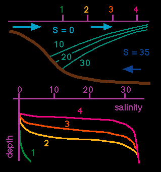 Figure 12.1
River volume R is very much larger than the tidal volume V, or there are no tides at all. The fresh water flows out over the sea water in a thin layer. All mixing is restricted to the thin transition layer between the fresh water at the top and the "wedge" of salt water underneath. Vertical salinity profiles therefore show zero salinity at the surface and oceanic salinity near the bottom all along the estuary. The depth of the interface decreases slowly as the outer end of the estuary is approached (Figure 12.1). Examples of large salt wedge estuaries are the Mississippi and the Congo Rivers. Other examples may be as small as only a few kilometers long. Note the vertical exaggeration in this and the following figures.
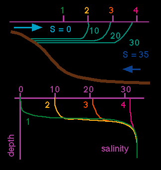 Figure 12.2
River volume R is comparable to but still larger than tidal volume V. Strong velocity shear at the interface produces internal wave motion at the transition between the two layers. The waves break and "topple over" in the upper layer, causing entrainment of salt water upward. Entrainment is a one-way process, so no fresh water is mixed downward. This results in a salinity increase for the upper layer, while the salinity in the lower layer remains unchanged, provided the lower layer volume is significantly larger than the river volume R and can sustain an unlimited supply of salt water (Figure 12.2). Examples of this type of estuary are fjords, which are usually very deep and have a large salt water reservoir below the upper layer. Moderately deep river beds often exhibit this type of stratification during periods of weak river flow.
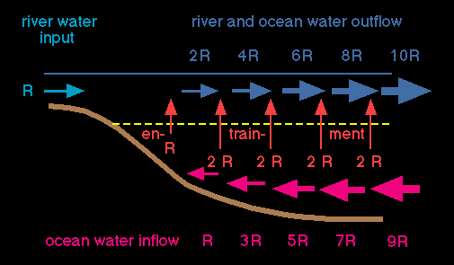 Figure 12.3
The upward mass flux of salt water leads to an increase of flow speed in the upper layer. This increase of mass transport in the upper layer can be quite significant, to the extent that the river output appears insignificant compared with the overall circulation (Figure 12.3). A 20-fold amplification of the mass transport into the sea is quite realistic. The surface velocity increases likewise, although not as dramatically, as the downstream increase in width of the estuary compensates for some of the increase in mass transport.
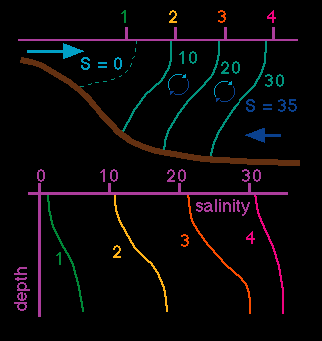 Figure 12.4
River volume R is small compared to tidal volume V. The tidal flow is turbulent through the entire water column (the turbulence induced mainly at the bottom). As a result, salt water is stirred into the upper layer and fresh water into the lower layer. Salinity therefore changes along the estuary axis not only in the upper layer (as was the case in the highly stratified estuary) but in both layers (Figure 12.4). There is some increase in surface velocity and upper layer transport towards the sea but not nearly as dramatic as in the highly stratified case. This type of estuary is widespread in temperate and subtropical climates; many examples are found around the world.
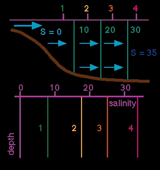 Figure 12.5
River volume R is insignificant compared with tidal volume V. Tidal mixing dominates the entire estuary. Locally it achieves complete mixing of the water column between surface and bottom, erasing all vertical stratification. As a result, vertical salinity profiles show uniform salinity but a salinity increase from station to station as the outer end of the estuary is approached (Figure 12.5). This type of estuary is found in regions of particularly strong tides; an example is the River Severn in England.
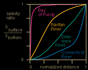 Figure 12.6
As said above, the estuary type is determined by the ratio R: V. Varying this ratio produces a range of salinity distributions, which can be classified by the ratio of surface salinity Ss against bottom salinity Sb. The ratio Ss: Sb can therefore be used as a substitute for the ratio R: V. Salinities are easier to measure than tidal and river volume, and a ratio based on salinities is therefore of practical value. Figure 12.6 shows the unified classification scheme based on salinity. The salt wedge estuary has freshwater at the surface, oceanic water at the bottom and is thus identified by a salinity ratio of zero. It occupies the bottom line of the diagram. Salinity in the vertically mixed estuary varies along the estuary but is the same at the surface and at the bottom everywhere, so the vertically mixed estuary has a salinity ratio of one and occupies the top line of the diagram. The highly stratified estuary is found in the lower right triangle, the slightly stratified estuary in the upper left triangle.
Estuaries can change type as a result of variations in rainfall and associated river flow. They may show different characteristics in different parts as a result of topographic restrictions on the propagation of the tide along the estuary which affect the tidal volume. The classification diagram can be used to establish changes of estuary type in space and time.
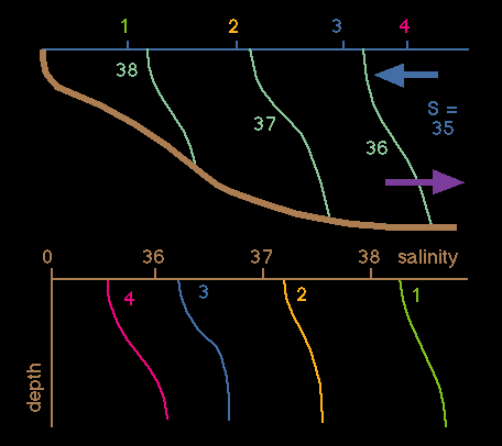 Figure 12.7
These estuaries have no fresh water input from rivers and are in a region of high evaporation. Surface salinity does not decrease from the ocean to the inner estuary, but water loss from evaporation leads to a salinity increase as the inner end of the estuary is approached (Figure 12.7). This results in a density increase and sinking of high salinity water at the inner end. As a result, movement of water is directed inward at the surface and towards the sea at the bottom, with sinking at the inward end. Compared to the estuaries discussed above their circulation is reversed, which explains the name inverse estuary.
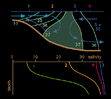 Figure 12.8
Some tropical Australian estuaries show a combination of 'normal' and 'inverse' circulation. Figure 12.8 shows the example of the Alligator River. The estuary receives some fresh water from river inflow but evaporation is so strong that at some intermediate position all river water has evaporated and salinity becomes higher than in the open sea. Upstream from this position the circulation is "normal"; downstream it is "inverse". Other examples are the Escape River and the Wenlock and Duncie Rivers.
Many estuaries change their classification type because of highly variable rainfall over the catchment area of their river input. River input may be small, but as long as some fresh water enters the estuary, the estuarine character is maintained (in the form of a salt wedge estuary). If the river input dries up completely during the dry season, estuaries loose their identity and turn into oceanic embayments. An example is the South West Arm of Port Hacking south of Sydney which turns into a highly stratified estuary for a few weeks after heavy rains.
During their estuarine periods intermittent estuaries can be classified on the basis of the classification diagram of Figure 12.6, but the effect of their high environmental variability on marine life is so overwhelming that a separate classification appears justified. Marine life in intermittent estuaries undergoes a complete change of communities between the estuarine and oceanic phases - very few plants or animals can cope with the salinity changes that occur between the two phases.