
![]()
![]()
![]()
![]()
The equation which describes motion in the ocean is derived from Newton's Second Law, which expresses conservation of momentum in the form force = mass times acceleration, or
F = m a
(Here, bold characters indicate vectors, characters in italics indicate scalars). In fluids this equation is expressed in terms of forces per unit mass F' = F/ m, so that
F' = dv / dt,
where v = (u,v,w) is the velocity in component notation along the axes x,y,z with x pointing east, y north and z downward (a = dv/dt is the acceleration). If there is more than one force, Newton's Second Law applies to the sum of all forces involved. The law applies in an absolute co-ordinate system, ie a system which is either stationary or moving at constant speed. Co-ordinate systems in oceanography are usually defined with their origin somewhere on the earth's surface (for example at the north pole). They are therefore neither stationary nor moving at constant speed but rotate with the Earth. If Newton's Second Law is expressed in a rotating coordinate system, it must include an apparent or virtual force which takes care of the effect of rotation. note
| external forces: (exerted on the fluid boundaries) | (a) tangential stress (force exerted by wind) |
(b) effects of thermo-haline driving (surface cooling, evaporation etc)
| |
| internal forces: (exerted on all water particles) | (c) Interior pressure field (pressure gradient) |
| (d) Tidal forces |
| (a) | Friction (diffusion of momentum) |
| (b) | Diffusion of density (not a force, but has the effect of changing the pressure gradient) |
Forces 1a) and 1b) act only at the boundaries; mathematically, they determine the boundary conditions of the geophysical problem but do not enter the equation of motion. Force 2a) acts on all water particles and is therefore part of the equation of motion (it is one of the forces in Newton's sum of forces). Force 2b) is not a force acting on water motion directly but changes the temperature and salinity fields and therefore the density; its effect is felt through the pressure field.
By taking the sum of all forces acting in the ocean Newton's Second Law takes the form
| particle acceleration = | - pressure gradient + Coriolis force + tidal force per unit mass + friction + gravity |
The tidal force needs only be considered in tidal problems; it can be ignored in a discussion of the general oceanic circulation.
Gravity does not exert a horizontal force and thus cannot produce horizontal acceleration; it is important in movement which involves vertical motion (convection, waves).
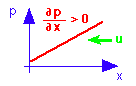
Why the negative sign for the pressure gradient? Because the acceleration produced by a pressure gradient is directed opposite to the gradient, so the assocated water movement is "down the gradient":
pressure p increases with increasing distance x (to the right), the pressure gradient is positive, the acceleration is from high pressure to low pressure, the current u flows down the pressure gradient (to the left).
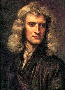
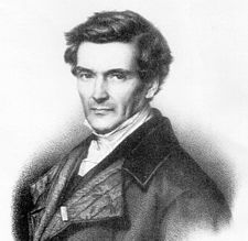
The Coriolis force (named after the French mathematician and engineer Gustave-Gaspard Coriolis, who described it in 1835) is an apparent force, that is, it is only apparent to an observer in a rotating frame of reference. To see this, consider a person standing on a merry-go-round, facing a ball thrown by a person from outside. To follow the ball the person would have to turn and therefore conclude that a force must be acting on the ball to deflect it from the shortest (straight) path. The person throwing the ball sees it follow a straight path and thus does not notice the force, and indeed the force does not exist for any person not on the merry-go-round. In oceanography currents are always expressed relative to the ocean floor - which rotates with the earth - and can therefore only be described correctly if the Coriolis force is taken into account in the balance of forces. The Coriolis force is proportional in magnitude to the flow speed and directed perpendicular to the direction of the flow. It acts to the left of the flow in the southern hemisphere and to the right in the northern hemisphere. A somewhat inaccurate but helpful way to see why the direction is different in the two hemispheres is related to the principle of conservation of angular momentum.
A water particle at rest at the equator carries angular momentum from the earth's rotation. When it is moved poleward it retains its angular momentum while its distance from the earth's axis is reduced. To conserve angular momentum it has to increase its rotation around the axis, just as ballet dancers increase their rate of rotation when pulling their arms towards their bodies (bringing them closer to their axis of rotation). The particle therefore starts spinning faster than the earth below it, ie it starts moving eastward.
 Animation
The effect of rotation on the apparent movement of objects can easily be demonstrated in laboratory experiments. You can see an example of such an experiment in the animation.
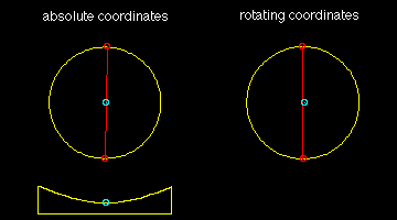
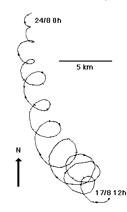 Figure 6.1
If a water parcel is given some momentum (pushed) and then left alone, the only force acting on it is the Coriolis force. Newton's Second Law then states that the parcel will accelerate at a constant rate. Since the acceleration is produced by the Coriolis force it is directed perpendicular to the parcel's path; in other words, the acceleration takes the form of a constant change of direction. The result is that the parcel moves on a circle.
Inertial motion is very common in the ocean, where it is usually found superimposed on other movement (such as geostrophic or wind-driven flow discussed below). Figure 6.1 gives an example from the Baltic Sea.
In the ocean interior, ie below about 100 m depth and about 100 km away from coastlines, frictional forces can be neglected. The steady state circulation is then determined by the balance between the pressure gradient force and the Coriolis force. This balance is known as geostrophic flow. In geostrophic flow particles move along isobars (contours of constant pressure), with high pressure on their left in the southern hemisphere, on their right in the northern hemisphere. Since the pressure at any depth is determined by the weight of the water above, high and low pressure are equivalent to high sea level and low sea level. Geostrophic flow is therefore related to the shape of the sea surface.
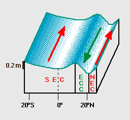 Figure 6.2
The Coriolis force and the pressure gradient force act on all water particles. Geostrophic flow is therefore part of the oceanic current field at all depths and locations. Below about 100 m depth and about 100 km away from coastlines all currents are geostrophic; closer to the surface and to boundaries they are modified by additional forces.
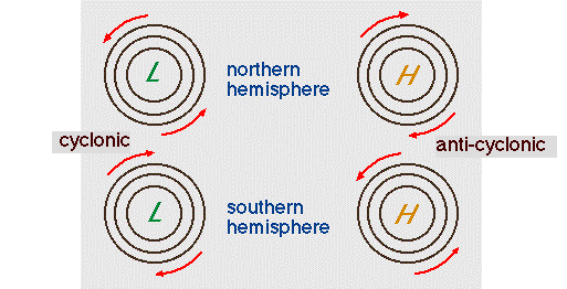 Figure 6.3
Figure 6.2 shows an example of geostrophic flow in the equatorial current system. Note that the variations in sea level are only of the order 0.2 - 0.4 m. These small variations are impossible to verify in the open ocean. They have, however, been varified in narrow straits, where a reversal of the current flowing through the strait produces a reversal of the sea surface tilt across the strait. The tilt can be measured with sea level gauges on both sides.
Another important aspect of geostrophic flow relates to the circulation around eddies. Figure 6.3 shows the principle. It applies equally to oceanic and atmospheric eddies and explains why a high pressure system to the east of Adelaide in South Australia brings northerly winds.
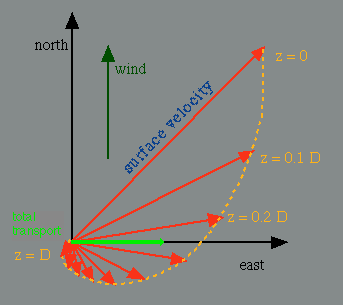 Figure 6.4
Currents in the upper 150 m or so of the ocean are directly affected by the wind, ie transfer of momentum from the atmosphere to the ocean. The balance of forces therefore involves frictional forces, which cause a departure from geostrophic flow; water moves across isobars from areas of high pressure to areas of low pressure. The layer in which the flow is non-geostrophic is known as the Ekman layer.
The direction of water movement in the Ekman layer varies with depth. The details are complicated (Figure 6.4); but when only the steady state is considered, an important result is that the net (i.e. vertically averaged) transport in the Ekman layer is directed perpendicular to the wind direction, to the left in the southern hemisphere and to the right in the northern hemisphere.
Upwelling is the process of vertical water movement to the surface of the ocean. Coastal and equatorial upwelling are responses to prevailing winds and provide direct evidence of Ekman transport dynamics. A third type of upwelling is not directly wind-related; it occurs in the Southern Ocean and is an element of the global conveyor belt.
 Figure 6.5