

![]()
![]()
![]()
![]()
![]()
The atmosphere and the ocean are both fluids in turbulent motion and follow the same physical laws. The Flinders University of South Australia recognises this by presenting meteorology and oceanography in the topic Marine Sciences 1 as a unit.
The following notes correspond roughly to the oceanography content of Marine Sciences 1.
A variety of textbooks offers coverage of physical oceanography at an introductory level. Most of these include a description of all aspects of marine sciences (i.e. including marine biology, geology and chemistry). Most are useful reference texts for physical oceanography.
Textbooks which cover only physical oceanography are usually much more detailed in their coverage than what is needed in an introductory course, but students with particular interest in physical oceanography aspects of earth sciences are encouraged to consult them as additional reference books. A list of books available in the library of Flinders University can be found here.
The classification number for physical oceanography in the Dewy classification system is 551.46; the easiest way to find what the library has to offer in this field is to walk up to the shelves labelled 551.46 and browse through the books.
 A-B Structures
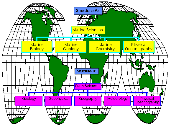
Physical oceanography occupies a unique place amongst all science disciplines because it has strong interactions with a large number of other sciences of very different characteristics. Universities usually follow one of two models in teaching physical oceanography. The first model emphasises the relationship between physical oceanography and other earth sciences disciplines:
 Figure: structure of Earth Sciences and Marine Sciences (Structure B).
The common characteristics of the earth sciences are that they study components of the planet earth and try to understand how they work, i.e. how the laws of physics and chemistry act to shape the earth as it is observed today and as it was in the past. In contrast to other sciences (physics, chemistry, biology), earth sciences can rarely control the conditions of their experiments. Their task is to collect data from the field and interpret them to the best of their abilities.
The second model groups physical oceanography together with all other marine science disciplines:
Figure: structure of Earth Sciences and Marine Sciences (Structure A).
The common characteristics of the marine sciences are the use of special research tools to study the oceans such as research vessels, submersibles, moorings and drifters. Some of the marine sciences also rely on successes and progress in other marine science disciplines. For example, marine biology often needs information about the physical environment; physical oceanography would not have the detailed knowledge about the deep ocean circulation without progress in ocean technology.
 Phys. Oceanography
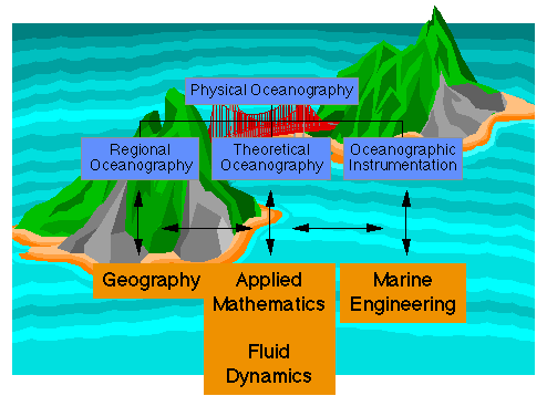
Physical Oceanography itself can be subdivided into three major streams:
Figure: structure of Physical Oceanography.
At Flinders University, all aspects of physical oceanography can be studied in a variety of ways depending on students' interests and strengths.
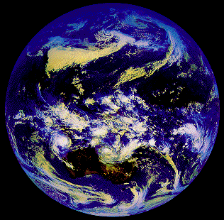 Figure 1.1
The ocean is a fluid in turbulent motion, ie it is characterised by the presence of turbulent eddies with velocities often larger than the velocities of the mean flow. As the atmosphere is also a fluid in turbulent motion it can be expected that the two media, the study objects of physical oceanography and meteorology, show similar behaviour and are governed by the same balance of forces and that it is therefore advantageous to study both together. To demonstrate the similarity, Figure 1.1 and Figure 1.2 show examples of eddies in the atmosphere and in the ocean. Note the difference in scale: Atmospheric eddies are typically some 2000 km in diameter, while oceanic eddy diameter are typically 200 km.
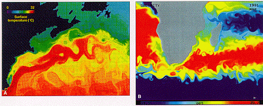 Figure 1.2
The aim of oceanography is an understanding of the oceanic circulation and the distribution of heat in the ocean, how the ocean interacts with the atmosphere, and what role the ocean plays in maintaining our climate.
An important tool in oceanography (as in all other earth sciences) is the atlas. People are used to looking up items of interest in an atlas, but few realise the importance of the correct choice of projections used for the maps.
A projection widely used in physical oceanography is the Mercator projection. It was developed in the 16th century at a time of colonial exploration and expanded sea travel. Columbus had discovered America and Magellan's ships had circled the globe. One problem faced by these mariners was the uncertainty involved in navigation away from the coast. In the 16th century a navigator had to sail between two points along a rhumb line (a line of constant compass bearing) because it was not practical to do otherwise. Mercator developed a projection that showed the earth's surface in such a way that a straight line on the resulting plane anywhere and in any direction was a rhumb line. Thus a mariner with a knowledge of the starting position could draw a straight line to the destination and read off the correct bearing.
As a result, Mercator's projection has become the standard projection for navigation. It is, however, not an equidistant or equal area projection and therefore unsuitable for mapping over large areas. It is a conformal map, i.e. small circles of equal area on the earth are represented as circles on the map but increase in size towards the poles. The poles cannot be shown in a Mercator projection, since distances near the poles grow to infinity.In principle, representation of a curved surface on a plane always involves some "stretching" or "shrinking" resulting in distortions, or some "tearing" resulting in interruption of the surface. No projection can satisfy all three desirable properties, i.e.
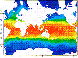 Figure 1.3
The three criteria are basic but mutually exclusive. All other properties are of a secondary nature. Most projections with the property of fidelity of area achieve area conservation through the use of a curved longitude grid and therefore require a grid drawn over the map surface to enable determination of geographical location coordinates (Figure 1.3). The Gall/Peters projection, which was developed by Gall in 1855 and rediscovered again independently by Peters in the 1970s, combines fidelity of area with a rectangular latitude/longitude grid. It is ideal for mapping large ocean regions.
The surface of the earth varies in height from 8848m (Mount Everest) to a depth of 11022 m (Vitiaz deep in the Mariana Trench, western North Pacific Ocean). On a geological time scale the position of the coastline depends on the amount of water available, which is mainly determined by the amount of ice and snow bound in Antarctica and in the Arctic Ocean, and to some degree by the temperature of the water in the ocean (water expands when warmed, so sea level rises during periods of warm climate). A characteristic of the land/water distribution of today, which has important ramifications for the climate, is that the area covered by water increases continuously from 70ºN to 60ºS:
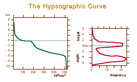 Figure 1.4
Water coverage of the earth: northern hemisphere 61%, southern hemisphere 81%, global average 71%.
"land hemisphere" 53% (pole off the Loire river in France), "water hemisphere" 89% (pole near New Zealand).
The present distribution of land and sea and the various depth levels is shown in the so-called hypsographic curve (Figure 1.4).
Average elevation -2440 m; mean land elevation +840 m, average ocean floor level -3795 m
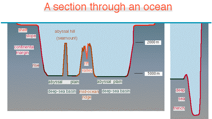 Figure 1.5
The major oceans are structured into continental margins, mid-ocean ridges and deep sea basins (Figure 1.5.). Each structural feature occupies about one third of the ocean floor.
| Topographic feature | Width | Depth | characteristics |
|---|---|---|---|
| Continental margins: | |||
| Shelf | up to 300 km wide | 150-200 m deep | |
| Slope | 20 - 100 km wide | from 200 to 2000 m deep | Often furrowed by canyons. Slopes 1 in 40. |
| Rise | up to 300 km wide | from 2000 to 5000 m deep | Slopes 1 in 700 to 1 in 1000 |
| Trench | 600 to 11,000 m deep | There are 26 trenches in the world ocean:
| |
| Deep sea basins | about 5000 m deep | ||
| Abyssal Plains | extremely flat, sediment-filled | ||
| Abyssal Hills | Rise from the plains up to 1000 m | ||
| Mid-ocean ridge: Interconnected mountain system | up to 400 km wide | Rises to 3000 - 1000 m | |
| Central rift valley | 20 - 50 km wide | cuts 1000 - 3000 m deep into the ridge system |
As noted the average depth of the oceans is just under 4 km. This is quite deep. Or is it ? If you use a divider and a very sharp pencil to draw a circle of 15 cm radius and take it to represent the earth then the pencil line would be thick enough to represent the crust of the Earth under continents (30 km) but much too thick for the oceanic crust (10 km). Irregularities in the line would be more than enough to represent the variation in the relief of the solid earth. So the ocean is really only a thin film of fluid - if the earth was a basketball, one would notice that much if its surface was damp.
There is no way of showing the oceans on a scale that preserves the aspect ratio of horizontal vs. vertical length. So how are we going to map ocean properties such as temperature, salinity or currents that vary considerably with depth? Compared to the ocean's vertical extent, horizontal distances are so large that the only way to produce a meaningful representation of the data is to distort the scales. A given distance on a diagram will thus represent several hundred times as much in real distance in the horizontal as in the vertical. A typical ratio is 500:1. This should be kept in mind when looking at oceanographic sections.